IMAGES TAKEN NEAR TO
Ilston Way, SWANSEA, SA3 5LG
Introduction
This page details the photographs taken nearby to Ilston Way, SA3 5LG by members of the Geograph project.
The Geograph project started in 2005 with the aim of publishing, organising and preserving representative images for every square kilometre of Great Britain, Ireland and the Isle of Man.

There are currently over 7.5m images from over14,400 individuals and you can help contribute to the project by visiting https://www.geograph.org.uk
Image Map (Loading...)


Getting Data...Please wait
Leaflet Map data © OpenStreetMap
Images are licensed for reuse under creativecommons.org/licenses/by-sa/2.0
Notes
- Clicking on the map will re-center to the selected point.
- The higher the marker number, the further away the image location is from the centre of the postcode.
Image Listing (46 Images Found)
Images are licensed for reuse under creativecommons.org/licenses/by-sa/2.0
Image
Details
Distance
1
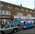
West Cross post office, Swansea
Located inside a Costcutter store in Alderwood Road.
Image: © Jaggery
Taken: 26 Feb 2012
0.08 miles
2
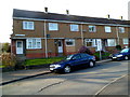
Houses at the southern end of Alderwood Road, West Cross, Swansea
Image: © Jaggery
Taken: 26 Feb 2012
0.08 miles
3
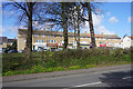
Row of shops at West Cross
Viewed across Mumbles Road which is the coast road.
Image: © Bill Boaden
Taken: 5 Apr 2016
0.08 miles
5
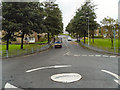
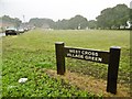
Fairwood Road/Mumbles Road
Mini roundabout at the junction of Fairwood Road with Mumbles Road (A4067).
Image: © David Dixon
Taken: 29 Aug 2012
0.10 miles
6
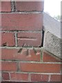
Ordnance Survey Cut Mark
This OS cut mark can be found at the top of the steps on West Cross Lane. It marks a point 15.597m above mean sea level.
Image: © Adrian Dust
Taken: 5 Mar 2014
0.10 miles
7
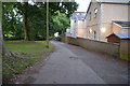
The Mumbles : Road
A small access road around the back of homes.
Image: © Lewis Clarke
Taken: 12 Aug 2017
0.10 miles
8
Mile Stone
This Mile Stone can be found in the hedge to the west of Mumbles Road. All information has eroded from it but there is an OS rivet on the top. http://www.geograph.org.uk/photo/3874658
Image: © Adrian Dust
Taken: 5 Mar 2014
0.12 miles
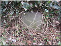
9
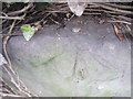
Ordnance Survey Rivet
This OS rivet can be found on the mile stone buried in the hedge to the west of Mumbles Road. It marks a point 10.634m above mean sea level. http://www.geograph.org.uk/photo/3874662
Image: © Adrian Dust
Taken: 5 Mar 2014
0.12 miles
10

Old Milestone by the A4067, Mumbles Road, West Cross
Stone post by the A4067, in parish of Mumbles (City and County of Swansea District), Mumbles Road, West Cross, in hedge behind pavement, West side of road, 100m North of West Cross Inn.
Inscription once read:-
(Swansea Castle)
(4)
(The Mumbles)
(1)
Carved bench mark and rivet on top.
Surveyed
Milestone Society National ID: GLA_SWOM04
Image: © Milestone Society
Taken: Unknown
0.12 miles