IMAGES TAKEN NEAR TO
Mayals Road, SWANSEA, SA3 5HQ
Introduction
This page details the photographs taken nearby to Mayals Road, SA3 5HQ by members of the Geograph project.
The Geograph project started in 2005 with the aim of publishing, organising and preserving representative images for every square kilometre of Great Britain, Ireland and the Isle of Man.

There are currently over 7.5m images from over14,400 individuals and you can help contribute to the project by visiting https://www.geograph.org.uk
Image Map (Loading...)


Getting Data...Please wait
Leaflet Map data © OpenStreetMap
Images are licensed for reuse under creativecommons.org/licenses/by-sa/2.0
Notes
- Clicking on the map will re-center to the selected point.
- The higher the marker number, the further away the image location is from the centre of the postcode.
Image Listing (12 Images Found)
Images are licensed for reuse under creativecommons.org/licenses/by-sa/2.0
Image
Details
Distance
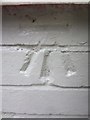
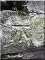
1
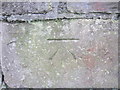
Ordnance Survey Cut Mark
This OS cut mark can be found on the wall of No197 Mayals Road. It marks a point 86.355m above mean sea level.
Image: © Adrian Dust
Taken: 5 Mar 2014
0.01 miles
2
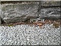
Ordnance Survey Flush Bracket (G3817)
This almost entirely buried OS Flush Bracket can be found on the garage of No199 Mayals Road.
Image: © Adrian Dust
Taken: 8 Dec 2022
0.05 miles
3
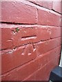
Ordnance Survey Cut Mark
This OS cut mark can be found on No28 Mulberry Avenue. It marks a point 71.415m above mean sea level.
Image: © Adrian Dust
Taken: 5 Mar 2014
0.10 miles
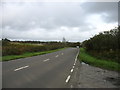
4
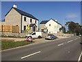
Mayals Road
New housing on B4436 on the outskirts of Mayals.
Image: © Alan Hughes
Taken: 19 Sep 2019
0.10 miles
5
Ordnance Survey Cut Mark
This OS cut mark can be found on No54 Fairwood Road. It marks a point 76.874m above mean sea level.
Image: © Adrian Dust
Taken: 5 Mar 2014
0.10 miles
6
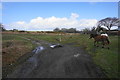
Path junction and ponies below Clyne Golf Club
The Mayals estate is to the right. The left path takes you up over the crest of the hill and through the golf course.
Image: © Bill Boaden
Taken: 6 Apr 2016
0.13 miles
7
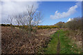
Path on the edge of Clyne Common
Unlike other paths on the common which are waterlogged, this path has a good solid base and is good to walk on.
Image: © Bill Boaden
Taken: 6 Apr 2016
0.14 miles
8
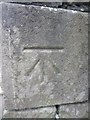
Ordnance Survey Cut Mark
This OS cut mark can be found on the wall of No142 Mayals Road. It marks a point 67.946m above mean sea level.
Image: © Adrian Dust
Taken: 5 Mar 2014
0.19 miles
10
Ordnance Survey Cut Mark
This OS cut mark can be found on the wall of Myrtle Cottage, Mayals Green. It marks a point 64.206m above mean sea level.
Image: © Adrian Dust
Taken: 5 Mar 2014
0.20 miles