IMAGES TAKEN NEAR TO
Brookvale Road, SWANSEA, SA3 5EX
Introduction
This page details the photographs taken nearby to Brookvale Road, SA3 5EX by members of the Geograph project.
The Geograph project started in 2005 with the aim of publishing, organising and preserving representative images for every square kilometre of Great Britain, Ireland and the Isle of Man.

There are currently over 7.5m images from over14,400 individuals and you can help contribute to the project by visiting https://www.geograph.org.uk
Image Map (Loading...)


Getting Data...Please wait
Leaflet Map data © OpenStreetMap
Images are licensed for reuse under creativecommons.org/licenses/by-sa/2.0
Notes
- Clicking on the map will re-center to the selected point.
- The higher the marker number, the further away the image location is from the centre of the postcode.
Image Listing (9 Images Found)
Images are licensed for reuse under creativecommons.org/licenses/by-sa/2.0
Image
Details
Distance
1
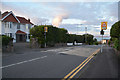
The Mumbles : Westcross Lane
Looking along Westcross Lane at The Mumbles.
Image: © Lewis Clarke
Taken: 12 Aug 2017
0.17 miles
2

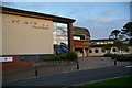
The Mumbles : Ysgol Gynradd Gymraeg Llwynderw
A school seen on West Cross Lane.
Image: © Lewis Clarke
Taken: 12 Aug 2017
0.18 miles
3
The Mumbles : Ysgol Gynradd Gymraeg Llwynderw
A school see on West Cross Lane.
Image: © Lewis Clarke
Taken: 12 Aug 2017
0.18 miles
4
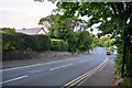
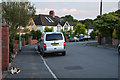
The Mumbles : West Cross Lane
Looking along West Cross Lane in The Mumbles.
Image: © Lewis Clarke
Taken: 12 Aug 2017
0.19 miles
5
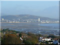
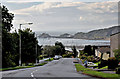
Swansea Bay from The Mumbles
Looking east to the industry and new apartment blocks of East Swansea.
Image: © Jonathan Billinger
Taken: 12 Nov 2008
0.20 miles
6
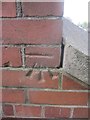
Ordnance Survey Cut Mark
This OS cut mark can be found on No66 Mulberry Avenue. It marks a point 65.017m above mean sea level.
Image: © Adrian Dust
Taken: 5 Mar 2014
0.22 miles
7
The Mumbles : Bellevue Road
Looking along Bellevue Road.
Image: © Lewis Clarke
Taken: 12 Aug 2017
0.22 miles
8
View of The Mumbles from Fairwood Avenue - West Cross
Image: © Mick Lobb
Taken: 21 Jul 2010
0.23 miles
9
Ordnance Survey Cut Mark
This OS cut mark can be found at the top of the steps on West Cross Lane. It marks a point 15.597m above mean sea level.
Image: © Adrian Dust
Taken: 5 Mar 2014
0.25 miles