IMAGES TAKEN NEAR TO
Westport Avenue, SWANSEA, SA3 5EA
Introduction
This page details the photographs taken nearby to Westport Avenue, SA3 5EA by members of the Geograph project.
The Geograph project started in 2005 with the aim of publishing, organising and preserving representative images for every square kilometre of Great Britain, Ireland and the Isle of Man.

There are currently over 7.5m images from over14,400 individuals and you can help contribute to the project by visiting https://www.geograph.org.uk
Image Map
Images are licensed for reuse under creativecommons.org/licenses/by-sa/2.0
Notes
- Clicking on the map will re-center to the selected point.
- The higher the marker number, the further away the image location is from the centre of the postcode.
Image Listing (11 Images Found)
Images are licensed for reuse under creativecommons.org/licenses/by-sa/2.0
Image
Details
Distance
1
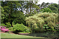
Swansea: Clyne Gardens
The gardens are open to the public. Looking north-north-west
Image: © Martin Bodman
Taken: 11 Jun 2006
0.10 miles
2
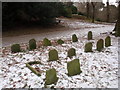
Pet Cemetery
Mynwent anifeiliaid anwes ym Mharc Clun,Dulais. Roedd yr anifeiliaid yn eiddo i'r teulu Vivian, cyn berchnogion Castell Clun, plasty crand gynt ond bellach yn fflatiau moethus.
A pet cemetery in Clyne Park, Blackpill. The animals belonged to the Vivian Family, the former owners of Clyne Castle. Today, the mansion has been converted into luxury apartments
Image: © Alan Richards
Taken: 10 Jan 2010
0.11 miles
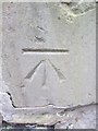
3
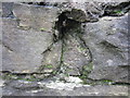
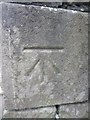
Ordnance Survey Cut Mark (Remains)
These remains can be found on the wall to the south of Mayals Road. It marked a point 53.800m above mean sea level.
Image: © Adrian Dust
Taken: 5 Mar 2014
0.14 miles
4
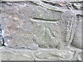
Ordnance Survey Cut Mark
This OS cut mark can be found on the wall at the entrance of the Le Breos Estate. It marks a point 63.395m above mean sea level.
Image: © Adrian Dust
Taken: 5 Mar 2014
0.16 miles
5
Ordnance Survey Cut Mark
This OS cut mark can be found on the wall of No142 Mayals Road. It marks a point 67.946m above mean sea level.
Image: © Adrian Dust
Taken: 5 Mar 2014
0.19 miles
6

Swansea: Clyne Gardens
The gardens are open to the public
Image: © Martin Bodman
Taken: 11 Jun 2006
0.20 miles
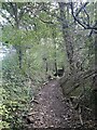
7
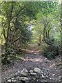
Old track from Clyne Castle to Clyne Farm
Image: © Alan Hughes
Taken: 20 Sep 2022
0.20 miles
9
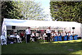
Band concert in Clyne Gardens
These concerts are held on Sunday afternoons in May.
Image: © john bristow
Taken: 26 May 2013
0.23 miles
10
Ordnance Survey Cut Mark
This OS cut mark can be found on the wall next to the Lodge on Mayals Road. It marks a point 36.149m above mean sea level.
Image: © Adrian Dust
Taken: 5 Mar 2014
0.23 miles