IMAGES TAKEN NEAR TO
Mayals Avenue, SWANSEA, SA3 5DB
Introduction
This page details the photographs taken nearby to Mayals Avenue, SA3 5DB by members of the Geograph project.
The Geograph project started in 2005 with the aim of publishing, organising and preserving representative images for every square kilometre of Great Britain, Ireland and the Isle of Man.

There are currently over 7.5m images from over14,400 individuals and you can help contribute to the project by visiting https://www.geograph.org.uk
Image Map
Images are licensed for reuse under creativecommons.org/licenses/by-sa/2.0
Notes
- Clicking on the map will re-center to the selected point.
- The higher the marker number, the further away the image location is from the centre of the postcode.
Image Listing (13 Images Found)
Images are licensed for reuse under creativecommons.org/licenses/by-sa/2.0
Image
Details
Distance
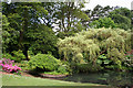
1

Swansea: Clyne Gardens
The gardens are open to the public
Image: © Martin Bodman
Taken: 11 Jun 2006
0.07 miles
2
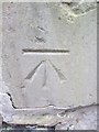
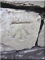
Ordnance Survey Cut Mark
This OS cut mark can be found on the wall next to the Lodge on Mayals Road. It marks a point 36.149m above mean sea level.
Image: © Adrian Dust
Taken: 5 Mar 2014
0.08 miles
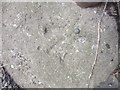
3
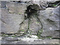
Ordnance Survey Cut Mark (Remains)
These remains can be found on the wall to the south of Mayals Road. It marked a point 53.800m above mean sea level.
Image: © Adrian Dust
Taken: 5 Mar 2014
0.14 miles
4
Swansea: Clyne Gardens
The gardens are open to the public. Looking north-north-west
Image: © Martin Bodman
Taken: 11 Jun 2006
0.19 miles
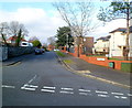
5
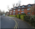
Llwynderw Drive houses, West Cross, Swansea
Viewed from the A4067 Mumbles Road end.
Image: © Jaggery
Taken: 26 Feb 2012
0.20 miles
6
Ordnance Survey Cut Mark
This OS cut mark can be found on the wall to the north of Mayals Road. It marks a point 19.053m above mean sea level.
Image: © Adrian Dust
Taken: 5 Mar 2014
0.20 miles
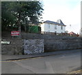
7
Huntington Close, West Cross, Swansea
Looking north along Huntington Close from Lilliput Lane.
Image: © Jaggery
Taken: 26 Feb 2012
0.21 miles
8

Musical entertainment in Clyne Gardens
This was the first Sunday of Clyne in Bloom for 2017.
Image: © john bristow
Taken: 7 May 2017
0.22 miles
9
Ordnance Survey Rivet
This OS rivet can be found at the base of the gate post of No164 Mumbles Road. It marks a point 9.199m above mean sea level.
Image: © Adrian Dust
Taken: 5 Mar 2014
0.23 miles
10
Dan-y-Coed House, Swansea
Owned by the City and County of Swansea Council, Dan-y-Coed House in Huntington Close,
West Cross, Swansea is a venue for small conferences and training events.
Image: © Jaggery
Taken: 26 Feb 2012
0.23 miles