IMAGES TAKEN NEAR TO
Heneage Drive, SWANSEA, SA3 5BR
Introduction
This page details the photographs taken nearby to Heneage Drive, SA3 5BR by members of the Geograph project.
The Geograph project started in 2005 with the aim of publishing, organising and preserving representative images for every square kilometre of Great Britain, Ireland and the Isle of Man.

There are currently over 7.5m images from over14,400 individuals and you can help contribute to the project by visiting https://www.geograph.org.uk
Image Map (Loading...)


Getting Data...Please wait
Leaflet Map data © OpenStreetMap
Images are licensed for reuse under creativecommons.org/licenses/by-sa/2.0
Notes
- Clicking on the map will re-center to the selected point.
- The higher the marker number, the further away the image location is from the centre of the postcode.
Image Listing (33 Images Found)
Images are licensed for reuse under creativecommons.org/licenses/by-sa/2.0
Image
Details
Distance
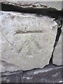
1
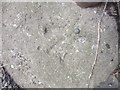
Ordnance Survey Rivet
This OS rivet can be found at the base of the gate post of No164 Mumbles Road. It marks a point 9.199m above mean sea level.
Image: © Adrian Dust
Taken: 5 Mar 2014
0.09 miles
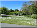
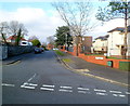
3
Llwynderw Drive houses, West Cross, Swansea
Viewed from the A4067 Mumbles Road end.
Image: © Jaggery
Taken: 26 Feb 2012
0.10 miles
4
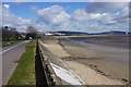
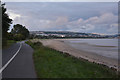
The seafront approaching Black Pill
There are continual views over Swansea Bay to Swansea.
Image: © Bill Boaden
Taken: 5 Apr 2016
0.11 miles
5
The Mumbles : Wales Coast Path
The coast path heads alongside Swansea Bay.
Image: © Lewis Clarke
Taken: 12 Aug 2017
0.12 miles
6
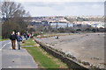
West Cross : Swansea Bay Cycle Path
Looking along the sandy shoreline of Swansea Bay and the path alongside it.
Image: © Lewis Clarke
Taken: 23 Mar 2014
0.12 miles
7
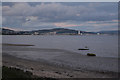
The Mumbles : Swansea Bay
Looking out across Swansea Bay.
Image: © Lewis Clarke
Taken: 12 Aug 2017
0.12 miles
8
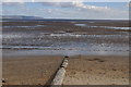
West Cross : Swansea Bay
Looking out across Swansea Bay from the shoreline.
Image: © Lewis Clarke
Taken: 23 Mar 2014
0.12 miles
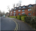
9
Huntington Close, West Cross, Swansea
Looking north along Huntington Close from Lilliput Lane.
Image: © Jaggery
Taken: 26 Feb 2012
0.13 miles
10
Ordnance Survey Cut Mark
This OS cut mark can be found on the wall to the north of Mayals Road. It marks a point 19.053m above mean sea level.
Image: © Adrian Dust
Taken: 5 Mar 2014
0.14 miles