IMAGES TAKEN NEAR TO
Maes Yr Eos, SWANSEA, SA3 5BQ
Introduction
This page details the photographs taken nearby to Maes Yr Eos, SA3 5BQ by members of the Geograph project.
The Geograph project started in 2005 with the aim of publishing, organising and preserving representative images for every square kilometre of Great Britain, Ireland and the Isle of Man.

There are currently over 7.5m images from over14,400 individuals and you can help contribute to the project by visiting https://www.geograph.org.uk
Image Map (7 Images)


Getting Data...Please wait
Leaflet Map data © OpenStreetMap
Images are licensed for reuse under creativecommons.org/licenses/by-sa/2.0
Notes
- Clicking on the map will re-center to the selected point.
- The higher the marker number, the further away the image location is from the centre of the postcode.
Image Listing (7 Images Found)
Images are licensed for reuse under creativecommons.org/licenses/by-sa/2.0
Image
Details
Distance
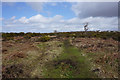
1
Small stream running off Clyne Common
Whilst it can easily be stepped over here, it will become the pill which emerges at Caswell Bay.
Image: © Bill Boaden
Taken: 6 Apr 2016
0.06 miles
2
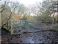
G?t Fochyn Comin Clun / Clyne Common Kissing Gate
Gât fochyn a chlwyd yn rhoi mynediad i Gomin Clun.
A kissing gate giving access to Clyne Common < Clun (trans. moorland).
Image: © Alan Richards
Taken: 6 Jan 2015
0.07 miles
3
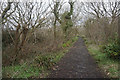
Path at the top of Highpool Lane
The path is a continuation of Highpool Lane leading onto Clyne Common. There is new housing development over to the right.
Image: © Bill Boaden
Taken: 6 Apr 2016
0.13 miles
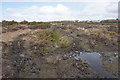
4
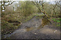
Path on Clyne Common
It doesn't look too bad on this image, but this part of Clyne Common is currently fairly waterlogged, making me think I might adjust my route.
Image: © Bill Boaden
Taken: 6 Apr 2016
0.14 miles
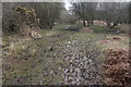
5
Path on Clyne Common
This shows the current state of this part of the common as fairly waterlogged. Ahead are some of the houses on the Chestnut Avenue estate.
Image: © Bill Boaden
Taken: 6 Apr 2016
0.20 miles
6
Path heading for the edge of Clyne Common
From experience on this occasion, the edges of the common are more waterlogged than the middle.
Image: © Bill Boaden
Taken: 6 Apr 2016
0.20 miles