IMAGES TAKEN NEAR TO
Whiteshell Drive, SWANSEA, SA3 4SY
Introduction
This page details the photographs taken nearby to Whiteshell Drive, SA3 4SY by members of the Geograph project.
The Geograph project started in 2005 with the aim of publishing, organising and preserving representative images for every square kilometre of Great Britain, Ireland and the Isle of Man.

There are currently over 7.5m images from over14,400 individuals and you can help contribute to the project by visiting https://www.geograph.org.uk
Image Map
Images are licensed for reuse under creativecommons.org/licenses/by-sa/2.0
Notes
- Clicking on the map will re-center to the selected point.
- The higher the marker number, the further away the image location is from the centre of the postcode.
Image Listing (62 Images Found)
Images are licensed for reuse under creativecommons.org/licenses/by-sa/2.0
Image
Details
Distance
1
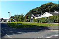
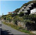
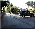
Whiteshell Drive, Langland, Swansea
On the west side of Brynfield Road, Whiteshell Drive leads to
Westwinds and Linkside, cul-de-sacs above Langland Bay Golf Club.
Image: © Jaggery
Taken: 12 Sep 2014
0.02 miles
2
Brynfield Road houses, Langland, Swansea
On the west side of a steep gradient from Langland Bay to Caswell Road.
Image: © Jaggery
Taken: 12 Sep 2014
0.06 miles
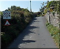
3
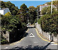
Start of a long steep climb away from Langland Bay, Swansea
Brynfield Road begins its ascent towards Caswell Road.
Image: © Jaggery
Taken: 12 Sep 2014
0.08 miles
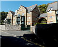
4
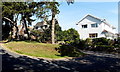
Houses on the east side of Brynfield Road, Langland, Swansea
At the top of Brynfield Road's long steep ascent from Langland Bay.
Image: © Jaggery
Taken: 12 Sep 2014
0.10 miles
5
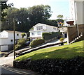
Steplike apartments in Langland, Swansea
Viewed across Langland Bay Road. The apartments in Links Court face Langland Bay.
Image: © Jaggery
Taken: 12 Sep 2014
0.12 miles
6
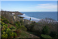
Hillside above Langlands Bay
The view is dominated by the excessively pretentious Victorian hotel buildings. The buildings are now apartments.
Image: © Bill Boaden
Taken: 2 Apr 2016
0.13 miles
7
This way to Langland Bay Golf Club, Swansea
The sign is alongside Langland Bay Road opposite Links Court apartments. http://www.geograph.org.uk/photo/4164983
Image: © Jaggery
Taken: 12 Sep 2014
0.13 miles
8
Outwardly opening entrance gates to Crawshay Court, Langland, Swansea
Notices on the gate piers caution that the electrically operated gates open outwards.
Image: © Jaggery
Taken: 12 Sep 2014
0.14 miles
9
Mary Twill Lane, Newton, Swansea
Mary Twill Lane heads SW away from the corner of Brynfield Road and Caswell Road.
This is one of the oldest routes in Newton - the lane appears in an early Victorian map. I could find no online reference to a local person named Mary Twill. One explanation would be if the name of the lane was an Anglicisation of an ancient Welsh name, but that's a guess.
Image: © Jaggery
Taken: 12 Sep 2014
0.14 miles
10
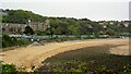
Langland Bay Beach Chalets
Behind the chalets is the WCIU Holiday & Convalescent Home built in baronial style. Viewed from the coastal path
Image: © Kevin Waterhouse
Taken: 5 May 2009
0.15 miles