IMAGES TAKEN NEAR TO
Newton Road, SWANSEA, SA3 4SW
Introduction
This page details the photographs taken nearby to Newton Road, SA3 4SW by members of the Geograph project.
The Geograph project started in 2005 with the aim of publishing, organising and preserving representative images for every square kilometre of Great Britain, Ireland and the Isle of Man.

There are currently over 7.5m images from over14,400 individuals and you can help contribute to the project by visiting https://www.geograph.org.uk
Image Map
Images are licensed for reuse under creativecommons.org/licenses/by-sa/2.0
Notes
- Clicking on the map will re-center to the selected point.
- The higher the marker number, the further away the image location is from the centre of the postcode.
Image Listing (53 Images Found)
Images are licensed for reuse under creativecommons.org/licenses/by-sa/2.0
Image
Details
Distance
1
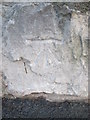
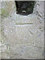
Ordnance Survey Cut Mark
This OS cut mark can be found on the wall of No106 Newton Road. It marks a point 30.660m above mean sea level.
Image: © Adrian Dust
Taken: 9 Feb 2016
0.04 miles
2
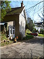
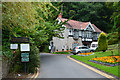
Oystermouth Cemetery office, Mumbles
The cemetery office is located near the Newton Road entrance http://www.geograph.org.uk/photo/2845727 to the cemetery.
Image: © Jaggery
Taken: 11 Mar 2012
0.06 miles
3
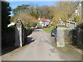
Southern entrance to Oystermouth Cemetery
This entrance from Newton Road is about 300 metres from the southern edge of the burial grounds. Oystermouth Cemetery opened for burials in 1883. It covers an area of about 28 acres (c11 hectares).
Image: © Jaggery
Taken: 11 Mar 2012
0.06 miles
4
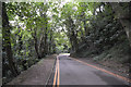
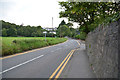
The Mumbles : Road
A road heading up the hill to Oystermouth Cemetery.
Image: © Lewis Clarke
Taken: 12 Aug 2017
0.09 miles
5

The Mumbles : Road
A road heading up the hill towards Oystermouth Cemetery.
Image: © Lewis Clarke
Taken: 12 Aug 2017
0.10 miles
6
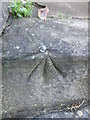
Ordnance Survey Cut Mark
This OS cut mark can be found on the wall of No118 Newton Road. It marks a point 54.407m above mean sea level.
Image: © Adrian Dust
Taken: 9 Feb 2016
0.10 miles
7
The Mumbles : Road
A road heading up towards Oystermouth Cemetery.
Image: © Lewis Clarke
Taken: 12 Aug 2017
0.10 miles
8
The Mumbles : Newton Road
Looking along Newton Road as it heads out from The Mumbles.
Image: © Lewis Clarke
Taken: 12 Aug 2017
0.10 miles
9

Newton News, Newton, Swansea
Newsagents and convenience store at 46 Southward Lane.
Image: © Jaggery
Taken: 12 Sep 2014
0.12 miles
10
Ordnance Survey Rivet
This OS rivet can be found on the step of No4 Nottage Road. It marks a point 66.251m above mean sea level.
Image: © Adrian Dust
Taken: 9 Feb 2016
0.13 miles