IMAGES TAKEN NEAR TO
Caswell, SWANSEA, SA3 4RF
Introduction
This page details the photographs taken nearby to SA3 4RF by members of the Geograph project.
The Geograph project started in 2005 with the aim of publishing, organising and preserving representative images for every square kilometre of Great Britain, Ireland and the Isle of Man.

There are currently over 7.5m images from over14,400 individuals and you can help contribute to the project by visiting https://www.geograph.org.uk
Image Map
Images are licensed for reuse under creativecommons.org/licenses/by-sa/2.0
Notes
- Clicking on the map will re-center to the selected point.
- The higher the marker number, the further away the image location is from the centre of the postcode.
Image Listing (9 Images Found)
Images are licensed for reuse under creativecommons.org/licenses/by-sa/2.0
Image
Details
Distance
1

The club house
Langland Bay golf course.
Image: © Jennifer Luther Thomas
Taken: 9 Dec 2006
0.14 miles
2
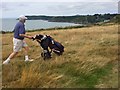
A good walk - and a good view - spoiled!
Golfer admiring the view over Caswell Bay .. while looking for his ball in the rough.
Image: © Alan Hughes
Taken: 6 Aug 2018
0.16 miles
3
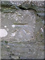
Ordnance Survey Cut Mark
This OS cut mark can be found on the wall on the south side of Caswell Road. It marks a point 45.479m above mean sea level.
Image: © Adrian Dust
Taken: 9 Feb 2016
0.19 miles
4
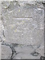
Ordnance Survey Cut Mark
This OS cut mark can be found on the wall on the north side of Caswell Road. It marks a point 72.631m above mean sea level.
Image: © Adrian Dust
Taken: 9 Feb 2016
0.19 miles
5
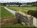
Langland Bay Golf Club
Track leading to the clubhouse at Langland Bay.
Image: © Alan Hughes
Taken: 6 Aug 2018
0.19 miles
7
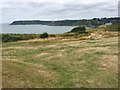
Newton Cliff above Caswell Bay
View from Newton Cliff across Caswell Bay.
Image: © Alan Hughes
Taken: 6 Aug 2018
0.24 miles
8
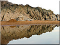
Rocks at Caswell
Rocks reflected in a pool on the east side of the beach at Caswell Bay.
Image: © Pam Brophy
Taken: 21 Apr 2007
0.25 miles
9
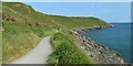
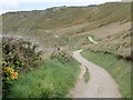
The Clifftop path to Langland Bay from Caswell Bay
This path will not please 'real' walkers with a metalled surface, seats at regular intervals and handrails at potential danger points, but the views can hardly be bettered and the route is extremely well used.
Image: © Philip Pankhurst
Taken: 11 Jun 2018
0.25 miles