IMAGES TAKEN NEAR TO
Hill Crest, SWANSEA, SA3 4PW
Introduction
This page details the photographs taken nearby to Hill Crest, SA3 4PW by members of the Geograph project.
The Geograph project started in 2005 with the aim of publishing, organising and preserving representative images for every square kilometre of Great Britain, Ireland and the Isle of Man.

There are currently over 7.5m images from over14,400 individuals and you can help contribute to the project by visiting https://www.geograph.org.uk
Image Map (Loading...)


Getting Data...Please wait
Leaflet Map data © OpenStreetMap
Images are licensed for reuse under creativecommons.org/licenses/by-sa/2.0
Notes
- Clicking on the map will re-center to the selected point.
- The higher the marker number, the further away the image location is from the centre of the postcode.
Image Listing (91 Images Found)
Images are licensed for reuse under creativecommons.org/licenses/by-sa/2.0
Image
Details
Distance
1
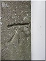
Ordnance Survey Cut Mark
This OS cut mark can be found on the SE angle of No45 Overland Road. It marks a point 32.556m above mean sea level.
Image: © Adrian Dust
Taken: 19 Mar 2014
0.11 miles
2
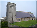
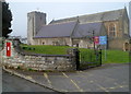
Grade II listed Parish Church of All Saints, Oystermouth, Swansea
Viewed from a road named Church Park. The first record of a church here was in 1141. There is evidence that the ancient Romans had a villa on this site. When the church building was being extended in 1860, workmen excavating the south side of the grounds found a tessellated Roman pavement (mosaic flooring).
The tower is Norman, built in an era of clashes between the native Welsh and the Anglo-Normans. The stairs in the tower ascend in an anticlockwise direction designed to ensure that the sword arm (right) remained free.
The church was Grade II listed in April 1952.
Image: © Jaggery
Taken: 11 Mar 2012
0.12 miles
4
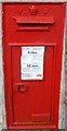
Victorian postbox, Oystermouth, Swansea
The postbox is in the perimeter wall of the Parish Church of All Saints.http://www.geograph.org.uk/photo/2845904
Image: © Jaggery
Taken: 11 Mar 2012
0.12 miles
5
A view from the SE of Grade II listed Parish Church of All Saints, Oystermouth, Swansea
Viewed from the corner of Church Park and Church Park Lane.
The first record of a church here was in 1141. There is evidence that the ancient Romans had a villa on this site. When the church building was being extended in 1860, workmen excavating the south side of the grounds found a tessellated Roman pavement (mosaic flooring).
The tower is Norman, built in an era of clashes between the native Welsh and the Anglo-Normans.
The stairs in the tower ascend in an anticlockwise direction designed to ensure that the sword arm (right) remained free.
The church was Grade II listed in April 1952.
http://www.geograph.org.uk/photo/2845913 to a closeup of the postbox.
Image: © Jaggery
Taken: 11 Mar 2012
0.12 miles
6
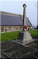
War Memorial outside All Saints Church, Oystermouth, Swansea
The Second World War Memorial is situated in the SW corner of All Saints http://www.geograph.org.uk/photo/2845884 churchyard.
It was dedicated on November 28th 1948. Below a cross of Portland Stone
are inscribed the names of 73 men and women of the district who were killed in the conflict.
The memorial for those killed in The Great War (later known as the First World War) is inside the church.
Image: © Jaggery
Taken: 11 Mar 2012
0.12 miles
7
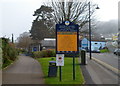
Entrance to Southend Gardens, Mumbles, Swansea
Facilities in Southend Gardens are crazy golf, http://www.geograph.org.uk/photo/1493401 a putting green, play area and toilets.
Image: © Jaggery
Taken: 11 Mar 2012
0.14 miles
8
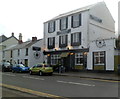
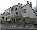
The Village Inn, Mumbles, Swansea
Brasserie at 580 Mumbles Road.
Image: © Jaggery
Taken: 11 Mar 2012
0.14 miles
9
The eastern end of Cambridge Road, The Mumbles
Image: © David Smith
Taken: 2 Jun 2018
0.14 miles
10
The Hancock, Mumbles
Viewed across Mumbles Road.
Located on the corner of Western Lane and Myrtle Terrace, The Hancock was previously The William Hancock. http://www.geograph.org.uk/photo/1493365 Behind it is Oystermouth Social Club. http://www.geograph.org.uk/photo/1493396
Image: © Jaggery
Taken: 11 Mar 2012
0.14 miles