IMAGES TAKEN NEAR TO
Higher Lane, SWANSEA, SA3 4PD
Introduction
This page details the photographs taken nearby to Higher Lane, SA3 4PD by members of the Geograph project.
The Geograph project started in 2005 with the aim of publishing, organising and preserving representative images for every square kilometre of Great Britain, Ireland and the Isle of Man.

There are currently over 7.5m images from over14,400 individuals and you can help contribute to the project by visiting https://www.geograph.org.uk
Image Map (Loading...)


Getting Data...Please wait
Leaflet Map data © OpenStreetMap
Images are licensed for reuse under creativecommons.org/licenses/by-sa/2.0
Notes
- Clicking on the map will re-center to the selected point.
- The higher the marker number, the further away the image location is from the centre of the postcode.
Image Listing (33 Images Found)
Images are licensed for reuse under creativecommons.org/licenses/by-sa/2.0
Image
Details
Distance
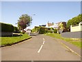
1
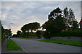
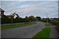
The Mumbles : Higher Lane
Looking along Higher Lane as it heads through The Mumbles.
Image: © Lewis Clarke
Taken: 12 Aug 2017
0.04 miles
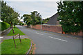
2
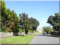
Higher Lane, Langland, Newton
It is a long time since this was really a lane
Image: © David Smith
Taken: 2 Jun 2018
0.04 miles
3
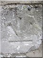
Ordnance Survey Cut Mark
This inverted OS cut mark can be found at the entrance to No63 Higher Lane. It marked a point 64.523m above mean sea level.
Image: © Adrian Dust
Taken: 19 Mar 2014
0.05 miles
4
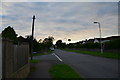
The Mumbles : Higher Lane
Looking along Higher Lane in The Mumbles.
Image: © Lewis Clarke
Taken: 12 Aug 2017
0.06 miles
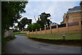
5
The eastern end of Cambridge Road, The Mumbles
Image: © David Smith
Taken: 2 Jun 2018
0.07 miles
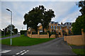
6
The Mumbles : Beaufort Avenue
From Higher Lane looking down Beaufort Avenue.
Image: © Lewis Clarke
Taken: 12 Aug 2017
0.07 miles
7
The Mumbles : Higher Lane
Looking along Higher Lane as it heads through the Mumbles.
Image: © Lewis Clarke
Taken: 12 Aug 2017
0.09 miles
8
The Mumbles : Channel View
Channel View seen from Higher Lane.
Image: © Lewis Clarke
Taken: 12 Aug 2017
0.09 miles
9
The Mumbles : Higher Lane
Looking along Higher Lane.
Image: © Lewis Clarke
Taken: 12 Aug 2017
0.14 miles
10
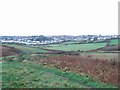
Thistleboon
Residential development between Limeslade and Langland.
Image: © Jennifer Luther Thomas
Taken: 25 Nov 2006
0.14 miles