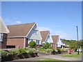
IMAGES TAKEN NEAR TO
Cleveland Avenue, SWANSEA, SA3 4JD
Introduction
This page details the photographs taken nearby to Cleveland Avenue, SA3 4JD by members of the Geograph project.
The Geograph project started in 2005 with the aim of publishing, organising and preserving representative images for every square kilometre of Great Britain, Ireland and the Isle of Man.

There are currently over 7.5m images from over14,400 individuals and you can help contribute to the project by visiting https://www.geograph.org.uk
Image Map
Images are licensed for reuse under creativecommons.org/licenses/by-sa/2.0
Notes
- Clicking on the map will re-center to the selected point.
- The higher the marker number, the further away the image location is from the centre of the postcode.
Image Listing (40 Images Found)
Images are licensed for reuse under creativecommons.org/licenses/by-sa/2.0
Image
Details
Distance
2
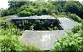
Command Post Bunker on Mumbles Hill
This was the command post that gave firing instructions to the guns of the 623rd Battery arranged around it. The building has had its doors and windows bricked up. It is surrounded by a fence, which explains why it has now become so overgrown.
Image: © Nigel Davies
Taken: 22 Jul 2012
0.14 miles
3
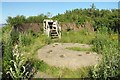
Gun emplacement on Mumbles Hill
This is one of the four main circular gun emplacements of the 623rd Battery. It is by far the best preserved but has lost a lot of its outer wall and has recently become quite overgrown.
Image: © Nigel Davies
Taken: 22 Jul 2012
0.16 miles
4
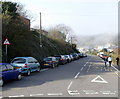
Plunch Lane, Mumbles, Swansea
Viewed across Mumbles Road, above Limeslade Bay. Plunch Lane heads towards Thistleboon.
Image: © Jaggery
Taken: 11 Mar 2012
0.18 miles
5
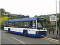
Free Bus to Swansea
A Leyland Lynx bus operating a free bus service to Swansea on the day of a transport rally.
Image: © David Roberts
Taken: Unknown
0.19 miles
6
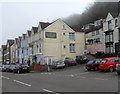
The Coast House B&B, Mumbles
Guest house with six rooms, located at 708 Mumbles Road.
Visibility was poor today (early March) in much of The Mumbles. Fog obscures part of the background of this view.
Image: © Jaggery
Taken: 11 Mar 2012
0.21 miles
7
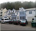
The George, Mumbles, Swansea
Large pub at 706 Mumbles Road, facing Swansea Bay. Previously named The Salt At The George.
Image: © Jaggery
Taken: 11 Mar 2012
0.21 miles
8
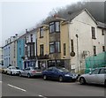
Shiraz, Mumbles, Swansea
Middle Eastern cuisine restaurant at 696 Mumbles Road.
The fencing on the right is part of the demolition site http://www.geograph.org.uk/photo/2846219 that was formerly The Famous Bear pub.
Image: © Jaggery
Taken: 11 Mar 2012
0.21 miles
9
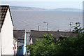
The Mumbles: view to Swansea
Looking across Swansea Bay from a point near Dickslade. A public footpath descends here from Mumbles Hill where there is a nature reserve
Image: © Martin Bodman
Taken: 10 Jun 2006
0.21 miles
10
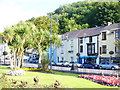
The Mumbles
The busy coastal road is limited in alignment by Swansea Bay and by Mumbles Hill. Formal gardens lie between the road and coastal path.
Image: © Colin Smith
Taken: 18 Jul 2009
0.22 miles