IMAGES TAKEN NEAR TO
Western Close, SWANSEA, SA3 4HF
Introduction
This page details the photographs taken nearby to Western Close, SA3 4HF by members of the Geograph project.
The Geograph project started in 2005 with the aim of publishing, organising and preserving representative images for every square kilometre of Great Britain, Ireland and the Isle of Man.

There are currently over 7.5m images from over14,400 individuals and you can help contribute to the project by visiting https://www.geograph.org.uk
Image Map
Images are licensed for reuse under creativecommons.org/licenses/by-sa/2.0
Notes
- Clicking on the map will re-center to the selected point.
- The higher the marker number, the further away the image location is from the centre of the postcode.
Image Listing (97 Images Found)
Images are licensed for reuse under creativecommons.org/licenses/by-sa/2.0
Image
Details
Distance
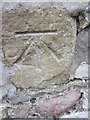
1
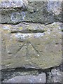
Ordnance Survey Cut Mark
This OS cut mark can be found on the wall at the junction of Village Lane & Western Lane. It marks a point 30.669m above mean sea level.
Image: © Adrian Dust
Taken: 19 Mar 2014
0.06 miles
2
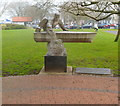
Breathing at Sea, an RNLI tribute, Mumbles, Swansea
The sculpture titled Breathing at Sea is in Southend Park, between Mumbles Road and Promenade Terrace, a few metres from the War Memorial. http://www.geograph.org.uk/photo/2846067 The work by Japanese sculptor Hideo Furuta was unveiled in 2002. The inscription on the plinth is:
A tribute to the enduring voluntary work of the Royal National Lifeboat Institution in The Mumbles,
in saving life at sea.
Image: © Jaggery
Taken: 11 Mar 2012
0.10 miles
3
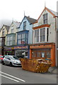
Three eateries, Mumbles Road, Mumbles, Swansea
In increasing distance from the camera are:
Sam Pan, Chinese and Cantonese cuisine.
Dragon Boat, Cantonese takeaway.
Mumbles Fast Food.
Image: © Jaggery
Taken: 11 Mar 2012
0.10 miles
4
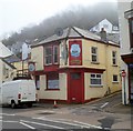
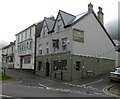
The Antelope, Mumbles, Swansea
Pub on the corner of Mumbles Road and Village Lane. The pub sign shows that The Antelope in question is a sailing ship.
Image: © Jaggery
Taken: 11 Mar 2012
0.10 miles
5
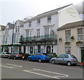
Patricks with Rooms, Mumbles, Swansea
Hotel at 638 Mumbles Road. There are 16 guest bedrooms, all en-suite, a restaurant, lounge bar and residents' gym.
Image: © Jaggery
Taken: 11 Mar 2012
0.10 miles
6
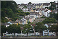
The Mumbles : Mumbles Scenery
Looking towards Village Lane with different coloured houses heading up the hillside.
Image: © Lewis Clarke
Taken: 12 Aug 2017
0.10 miles
7

Mumbles War Memorial, Swansea
Located in Southend Gardens, between Mumbles Road and Promenade Terrace.
Image: © Jaggery
Taken: 11 Mar 2012
0.10 miles
8
Moonlight, Mumbles, Swansea
Indian restaurant and takeaway at 590 Mumbles Road, next door to Mumbles RFC's clubhouse. http://www.geograph.org.uk/photo/2846018
Image: © Jaggery
Taken: 11 Mar 2012
0.10 miles
9
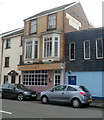
The Hancock, Mumbles
Viewed across Mumbles Road.
Located on the corner of Western Lane and Myrtle Terrace, The Hancock was previously The William Hancock. http://www.geograph.org.uk/photo/1493365 Behind it is Oystermouth Social Club. http://www.geograph.org.uk/photo/1493396
Image: © Jaggery
Taken: 11 Mar 2012
0.10 miles
10
Ordnance Survey Cut Mark
This OS cut mark can be found on the wall to the east of the junction of Western Lane & Overland Road. It marks a point 15.682m above mean sea level.
Image: © Adrian Dust
Taken: 19 Mar 2014
0.12 miles