1
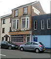
The Hancock, Mumbles
Viewed across Mumbles Road.
Located on the corner of Western Lane and Myrtle Terrace, The Hancock was previously The William Hancock. http://www.geograph.org.uk/photo/1493365 Behind it is Oystermouth Social Club. http://www.geograph.org.uk/photo/1493396
Image: © Jaggery
Taken: 11 Mar 2012
0.01 miles
2
Moonlight, Mumbles, Swansea
Indian restaurant and takeaway at 590 Mumbles Road, next door to Mumbles RFC's clubhouse. http://www.geograph.org.uk/photo/2846018
Image: © Jaggery
Taken: 11 Mar 2012
0.01 miles
3
Mumbles War Memorial, Swansea
Located in Southend Gardens, between Mumbles Road and Promenade Terrace.
Image: © Jaggery
Taken: 11 Mar 2012
0.01 miles
4
Ordnance Survey Cut Mark
This OS cut mark can be found on the wall to the east of the junction of Western Lane & Overland Road. It marks a point 15.682m above mean sea level.
Image: © Adrian Dust
Taken: 19 Mar 2014
0.03 miles
5
Ordnance Survey Cut Mark
This OS cut mark can be found on the wall at the junction of Village Lane & Western Lane. It marks a point 30.669m above mean sea level.
Image: © Adrian Dust
Taken: 19 Mar 2014
0.04 miles
6
Western Lane, Mumbles
Looking up Western Lane past the William Hancock.
Image: © Pierre Terre
Taken: 24 Aug 2009
0.04 miles
7
Western Lane, Mumbles
Looking towards the Oystermouth Social Club from Mumbles road.
Image: © Pierre Terre
Taken: 24 Aug 2009
0.05 miles
8
Three eateries, Mumbles Road, Mumbles, Swansea
In increasing distance from the camera are:
Sam Pan, Chinese and Cantonese cuisine.
Dragon Boat, Cantonese takeaway.
Mumbles Fast Food.
Image: © Jaggery
Taken: 11 Mar 2012
0.05 miles
9
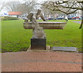
Breathing at Sea, an RNLI tribute, Mumbles, Swansea
The sculpture titled Breathing at Sea is in Southend Park, between Mumbles Road and Promenade Terrace, a few metres from the War Memorial. http://www.geograph.org.uk/photo/2846067 The work by Japanese sculptor Hideo Furuta was unveiled in 2002. The inscription on the plinth is:
A tribute to the enduring voluntary work of the Royal National Lifeboat Institution in The Mumbles,
in saving life at sea.
Image: © Jaggery
Taken: 11 Mar 2012
0.05 miles
10
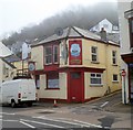
The Antelope, Mumbles, Swansea
Pub on the corner of Mumbles Road and Village Lane. The pub sign shows that The Antelope in question is a sailing ship.
Image: © Jaggery
Taken: 11 Mar 2012
0.05 miles


