IMAGES TAKEN NEAR TO
Newton Road, SWANSEA, SA3 4AT
Introduction
This page details the photographs taken nearby to Newton Road, SA3 4AT by members of the Geograph project.
The Geograph project started in 2005 with the aim of publishing, organising and preserving representative images for every square kilometre of Great Britain, Ireland and the Isle of Man.

There are currently over 7.5m images from over14,400 individuals and you can help contribute to the project by visiting https://www.geograph.org.uk
Image Map
Images are licensed for reuse under creativecommons.org/licenses/by-sa/2.0
Notes
- Clicking on the map will re-center to the selected point.
- The higher the marker number, the further away the image location is from the centre of the postcode.
Image Listing (150 Images Found)
Images are licensed for reuse under creativecommons.org/licenses/by-sa/2.0
Image
Details
Distance
1
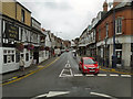
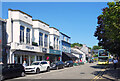
Oystermouth
Looking up Newton Road, The White Rose public house is on the left.
Image: © David Dixon
Taken: 29 Aug 2012
0.02 miles
2
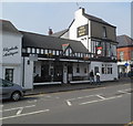
The White Rose, Mumbles, Swansea
Pub on the corner of Mumbles Road and Newton Road.
Image: © Jaggery
Taken: 11 Mar 2012
0.03 miles
3
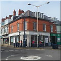
HSBC Mumbles branch, Swansea
Bank branch at 2 Newton Road.
Image: © Jaggery
Taken: 11 Mar 2012
0.03 miles
4
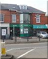
Mumbles branch, Swansea Building Society
Located at 496 Mumbles Road, next door to HSBC. http://www.geograph.org.uk/photo/2844497
Swansea Building Society was founded as a mutual building society in 1923.
Image: © Jaggery
Taken: 11 Mar 2012
0.03 miles
5
Lloyds TSB Mumbles branch, Swansea
Bank branch at 10 Newton Road, Mumbles, Swansea.
Image: © Jaggery
Taken: 11 Mar 2012
0.03 miles
6
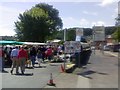
The dairy car park
The second Saturday of the month sees the appearance of the farmers market.
Image: © David Luther Thomas
Taken: 14 Jul 2007
0.04 miles
7
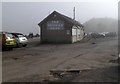
Oystermouth Square Caf?, Mumbles, Swansea
Viewed on a foggy day in early March. Located on the edge of Swansea Bay, The Square Café opened in 2009. The building was the Mumbles Railway ticket office and waiting room from 1898 until January 1960 when the railway closed. The building's later uses include bus station, tourist information centre and taxi office.
Image: © Jaggery
Taken: 11 Mar 2012
0.04 miles
8
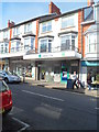
Shop Fronts, Mumbles Road
A short terrace of shops with a bit extra added to the top of the facade for effect.
Image: © Des Blenkinsopp
Taken: 19 Jul 2021
0.04 miles
9
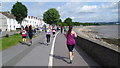
Part of the route of the 2015 Swansea Half Marathon
Runners on their return leg to Swansea pass Norton Road.
Image: © Jeremy Bolwell
Taken: 14 Jun 2015
0.05 miles
10
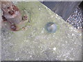
Ordnance Survey Bolt
This OSBM Bolt can be found on the top of the beach steps. It marks a point 6.478m above mean sea level.
Image: © Adrian Dust
Taken: 19 Mar 2014
0.05 miles