IMAGES TAKEN NEAR TO
Glandwr, WHITLAND, SA34 0YJ
Introduction
This page details the photographs taken nearby to SA34 0YJ by members of the Geograph project.
The Geograph project started in 2005 with the aim of publishing, organising and preserving representative images for every square kilometre of Great Britain, Ireland and the Isle of Man.

There are currently over 7.5m images from over14,400 individuals and you can help contribute to the project by visiting https://www.geograph.org.uk
Image Map (Loading...)


Getting Data...Please wait
Leaflet Map data © OpenStreetMap
Images are licensed for reuse under creativecommons.org/licenses/by-sa/2.0
Notes
- Clicking on the map will re-center to the selected point.
- The higher the marker number, the further away the image location is from the centre of the postcode.
Image Listing (3 Images Found)
Images are licensed for reuse under creativecommons.org/licenses/by-sa/2.0
Image
Details
Distance
2
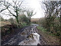
Llwybr yn cyrraedd yr heol / Path approaching the road
Llwybr troed cyhoeddus yn agosau at heol fach
A public footpath approaches a minor road.
Image: © Alan Richards
Taken: 23 Feb 2024
0.17 miles
3
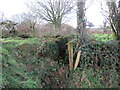
Llwybr Capel Glandwr / Glandwr Chapel path
Sticil garreg ar lwybr troed cyhoeddus uwchben Capel Glandwr.
A stone stile on a public footpath above Glandwr (trans. riverside) Chapel.
Image: © Alan Richards
Taken: 23 Feb 2024
0.22 miles