IMAGES TAKEN NEAR TO
Glandwr, WHITLAND, SA34 0YB
Introduction
This page details the photographs taken nearby to SA34 0YB by members of the Geograph project.
The Geograph project started in 2005 with the aim of publishing, organising and preserving representative images for every square kilometre of Great Britain, Ireland and the Isle of Man.

There are currently over 7.5m images from over14,400 individuals and you can help contribute to the project by visiting https://www.geograph.org.uk
Image Map
Images are licensed for reuse under creativecommons.org/licenses/by-sa/2.0
Notes
- Clicking on the map will re-center to the selected point.
- The higher the marker number, the further away the image location is from the centre of the postcode.
Image Listing (14 Images Found)
Images are licensed for reuse under creativecommons.org/licenses/by-sa/2.0
Image
Details
Distance
1
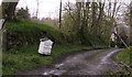
Aberelwyn Mill sign
Old bee hive used as base for name of property, cannot remember there being honey for sale here, only stoves!
Image: © chris whitehouse
Taken: 27 Apr 2012
0.03 miles
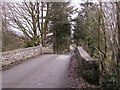
2
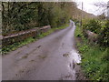
Bridge over Nant Elwyn near Aberelwyn
Nant Elwyn flows towards Glandwr to meet with Afon Gavel by bridge Image Date stone detail of this bridge shown inImage
Image: © chris whitehouse
Taken: 27 Apr 2012
0.05 miles
3
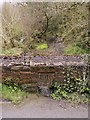
Date stone in bridge over Nant Elwyn
Nant Elwyn flows towards Glandwr to meet with Afon Gavel by bridge Image
Image: © chris whitehouse
Taken: 27 Apr 2012
0.06 miles
4
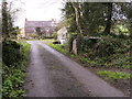
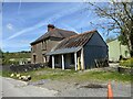
Gate posts at Aberelywn
Unusual construction of gate posts, slabs of slate tied together with iron rods to make a box to hang the (missing) gate on, normal posts in this area were of stone, on right is field entrance with stone posts but no gate (not visible). This road from Rhydowen drives through the farm yard and out through another opening again posts but no gate.
Image: © chris whitehouse
Taken: 27 Apr 2012
0.10 miles
5
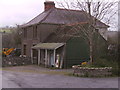
Rhydowen's shop and filling station
Many years ago this house and building was a shop with petrol pump outside, now a transport business. Across the road is Station House and what was Rhydowen Station.
Image: © chris whitehouse
Taken: 27 Apr 2012
0.13 miles
7
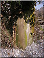
Last remaining level crossing gate latch post
This post is all that remains of the level crossing at Rhydowen Station, on the "Cardi Bach" Whitland to Cardigan Railway, that was closed about 1962. This post was the "latch post" that the crossing gate locked onto, in the shadows and ivy is the lock plate still in its place. There is a pair of posts from the same level crossing, but from the gate on the other side of the road, behind me but not vertical or in their original location, see Image
Image: © chris whitehouse
Taken: 10 Apr 2015
0.14 miles
8
Rhydowen railway station (site), Ceredigion
Opened in 1875 by the Whitland and Taf Vale Railway, later part of the Great Western Railway, on the line from Whitland to Cardigan, this station closed in 1962.
View south along the former track-bed towards Llanglydwen and Whitland from the former level crossing. The single-platform station was to the far left of the image. No trace apparently remains.
For more information, see http://www.disused-stations.org.uk/r/rhydowen/index.shtml.
Image: © Nigel Thompson
Taken: 3 Sep 2022
0.17 miles
9
Looking towards Rhydowen over bridge
This bridge has a bit of a "hump" on it! enough for vehicles to meet with an accident.
Image: © chris whitehouse
Taken: 14 Feb 2012
0.18 miles
10
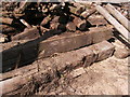
Recumbent level crossing posts
This is the pair of gate posts from the level crossing at Rhydowen Station, now holding back Mr. Wilshaw's fire wood stock. The hinges are visible on the upper post with brackets and latch still in place on the lower post. Many thanks to Mr & Mrs C Wilshaw for permission to photograph these remnants of "Cardi Bach" Railway, that closed about 1962, and the track was removed a couple of years later. I understand the track was exported abroad and relaid.
Image: © chris whitehouse
Taken: 10 Apr 2015
0.20 miles