IMAGES TAKEN NEAR TO
Henllan Amgoed, WHITLAND, SA34 0SJ
Introduction
This page details the photographs taken nearby to SA34 0SJ by members of the Geograph project.
The Geograph project started in 2005 with the aim of publishing, organising and preserving representative images for every square kilometre of Great Britain, Ireland and the Isle of Man.

There are currently over 7.5m images from over14,400 individuals and you can help contribute to the project by visiting https://www.geograph.org.uk
Image Map
Images are licensed for reuse under creativecommons.org/licenses/by-sa/2.0
Notes
- Clicking on the map will re-center to the selected point.
- The higher the marker number, the further away the image location is from the centre of the postcode.
Image Listing (78 Images Found)
Images are licensed for reuse under creativecommons.org/licenses/by-sa/2.0
Image
Details
Distance
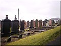
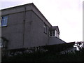
2
Henllan Amgoed Chapel - back wall and farm lane
Image: © welshbabe
Taken: 8 Mar 2013
0.16 miles
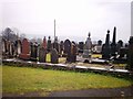
3
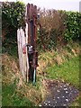
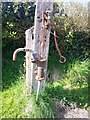
Old Pump, Henllan Chapel north of Whitland
Image: © welshbabe
Taken: 19 Feb 2013
0.18 miles

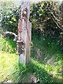
7
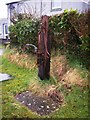
Old Pump, Henllan Chapel north of Whitland
Image: © welshbabe
Taken: 19 Feb 2013
0.19 miles
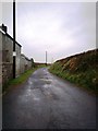
8
Entrance to the gallery
The third entrance to the Chapel, the steps lead from the car park up to the gallery, access to the car park is from the drive of Caeremlyn.
Image: © chris whitehouse
Taken: 15 Feb 2013
0.19 miles