IMAGES TAKEN NEAR TO
WHITLAND, SA34 0QR
Introduction
This page details the photographs taken nearby to SA34 0QR by members of the Geograph project.
The Geograph project started in 2005 with the aim of publishing, organising and preserving representative images for every square kilometre of Great Britain, Ireland and the Isle of Man.

There are currently over 7.5m images from over14,400 individuals and you can help contribute to the project by visiting https://www.geograph.org.uk
Image Map (Loading...)


Getting Data...Please wait
Leaflet Map data © OpenStreetMap
Images are licensed for reuse under creativecommons.org/licenses/by-sa/2.0
Notes
- Clicking on the map will re-center to the selected point.
- The higher the marker number, the further away the image location is from the centre of the postcode.
Image Listing (77 Images Found)
Images are licensed for reuse under creativecommons.org/licenses/by-sa/2.0
Image
Details
Distance
1
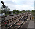
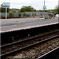
Junction west of Whitland railway station
Viewed from platform 1 at Whitland railway station. The twin tracks straight ahead are towards the terminus at Milford Haven via Haverfordwest. Next station ahead on this route is Clunderwen. The single track line diverging on the left is towards the terminus at Pembroke Dock, via Tenby. Next station ahead on this route is Narberth.
Image: © Jaggery
Taken: 21 May 2015
0.15 miles
2
Whitland Station
The two main lines continue toward Clarbeston Road while the Pembroke Dock branch goes left beyond the platforms.
Image: © Peter Whatley
Taken: 24 Jul 2009
0.16 miles
3
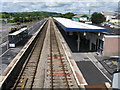
Through Whitland railway station
From the station footbridge. The passenger shelters on platform 2 contrast with the long canopy over platform 1. The bay platform on the left is not in regular use, but the absence of weeds suggests that the line alongside it is used occasionally. In the distance, the line to Pembroke Dock diverges from the line to Milford Haven.
Image: © Jaggery
Taken: 21 May 2015
0.16 miles
4
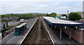
South side of Whitland railway station
Viewed from the station footbridge. http://www.geograph.org.uk/photo/4488089 The two platforms on the right are used for scheduled services.
The absence of weeds on and alongside the track at the bay (dead end) platform suggests that
this platform is used occasionally, though trains do not usually terminate at Whitland.
Image: © Jaggery
Taken: 11 Aug 2015
0.17 miles
5
Bilingual name signs, Whitland railway station
The Welsh name for Whitland is Hendy-gwyn, literally Old White House.
Image: © Jaggery
Taken: 21 May 2015
0.18 miles
6
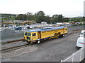
Track maintenance vehicle
In the railway yard, Whitland.
Image: © Roger Cornfoot
Taken: 9 Oct 2008
0.19 miles
7
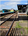
Whitland railway station from Station Road level crossing
The Arriva Trains Wales train at platform 2 awaits departure for Milford Haven.
Image: © Jaggery
Taken: 21 May 2015
0.19 miles
8
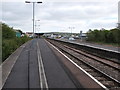
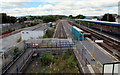
Long platforms at Whitland railway station
Much longer than trains (2 or 3 coaches) stopping here in May 2015, the platforms extend for nearly 200 metres.
Image: © Jaggery
Taken: 21 May 2015
0.19 miles
9
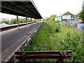
Weeds cover a long disused line of the north side of Whitland railway station
Viewed in May 2015. This is a long disused former bay platform at Whitland, a railway station much reduced from its former glory. Now only two platforms are in regular use, though the bay platform http://www.geograph.org.uk/photo/4486847 on the other side of the station looks to be used occasionally. Penderi Furniture http://www.geograph.org.uk/photo/4486833 is on the right.
Image: © Jaggery
Taken: 21 May 2015
0.20 miles
10
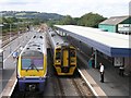
Whitland railway station
Two trains pass each other in Whitland station - neither appears to be an Arriva train though, the main company that operates this line - other companies occasionally run services along this line too.
Just beyond the station, the branch (to the left) to Pembroke Dock can be seen just beyond the semaphore signal.
Image: © Hywel Williams
Taken: 28 Jul 2007
0.20 miles