IMAGES TAKEN NEAR TO
WHITLAND, SA34 0LR
Introduction
This page details the photographs taken nearby to SA34 0LR by members of the Geograph project.
The Geograph project started in 2005 with the aim of publishing, organising and preserving representative images for every square kilometre of Great Britain, Ireland and the Isle of Man.

There are currently over 7.5m images from over14,400 individuals and you can help contribute to the project by visiting https://www.geograph.org.uk
Image Map (Loading...)


Getting Data...Please wait
Leaflet Map data © OpenStreetMap
Images are licensed for reuse under creativecommons.org/licenses/by-sa/2.0
Notes
- Clicking on the map will re-center to the selected point.
- The higher the marker number, the further away the image location is from the centre of the postcode.
Image Listing (11 Images Found)
Images are licensed for reuse under creativecommons.org/licenses/by-sa/2.0
Image
Details
Distance
1
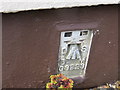
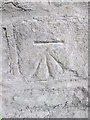
Ordnance Survey Flush Bracket G3223
This can be found on the wall of Nant House.
For more detail see : http://www.bench-marks.org.uk/log?bm_key=15080
Image: © Peter Wood
Taken: 23 May 2013
0.00 miles
2
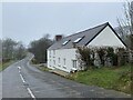
Solitary house
House on the old Whitland Road.
Image: © Alan Hughes
Taken: 26 Feb 2021
0.00 miles
3
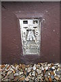
Ordnance Survey Flush Bracket (G3223)
This OS Flush Bracket can be found on Nant House to the north of the road. It marks a point 28.542m above mean sea level.
Image: © Adrian Dust
Taken: 6 Jul 2014
0.01 miles
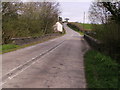
4
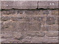
Bench Mark
Bridge on old A40 at Penybank with bench mark (58 feet)
Image: © chris whitehouse
Taken: 13 Apr 2012
0.03 miles
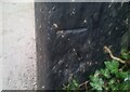
5
Ordnance Survey Cut Mark
This OS cut mark can be found on the north parapet of Pont Yr Allwyn. It marks a point 27.981m above mean sea level.
Image: © Adrian Dust
Taken: 6 Jul 2014
0.04 miles
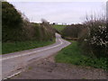
6
A40 pre bypass
Old A40 road crosses bridge over Nant yr Allwyn
Image: © chris whitehouse
Taken: 13 Apr 2012
0.05 miles

8
A40 pre bypass
Looking below Penygraig Farm along the old A40 to the bridge at Penybank.
Image: © chris whitehouse
Taken: 13 Apr 2012
0.08 miles
9
Ordnance Survey Cut Mark
This OS cut mark can be found on the gatepost of Penrhiw Cottage. It marks a point 43.189m above mean sea level.
Image: © Adrian Dust
Taken: 10 Jan 2022
0.09 miles
10
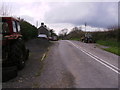
Farm equipment at Penygraig Farm
Now this part of the old A40 is semi redundant, the farm equipment is parked with out fear of causing accidents.
Image: © chris whitehouse
Taken: 13 Apr 2012
0.14 miles