IMAGES TAKEN NEAR TO
Hebron, WHITLAND, SA34 0JX
Introduction
This page details the photographs taken nearby to SA34 0JX by members of the Geograph project.
The Geograph project started in 2005 with the aim of publishing, organising and preserving representative images for every square kilometre of Great Britain, Ireland and the Isle of Man.

There are currently over 7.5m images from over14,400 individuals and you can help contribute to the project by visiting https://www.geograph.org.uk
Image Map
Images are licensed for reuse under creativecommons.org/licenses/by-sa/2.0
Notes
- Clicking on the map will re-center to the selected point.
- The higher the marker number, the further away the image location is from the centre of the postcode.
Image Listing (3 Images Found)
Images are licensed for reuse under creativecommons.org/licenses/by-sa/2.0
Image
Details
Distance
1
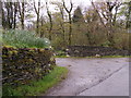
Silvio's excellent dry stone walling
A local craftsman built this entrance wall at Pen-celli Organic Growers.
Image: © chris whitehouse
Taken: 27 Apr 2012
0.10 miles
2
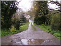
Driveway to Pen-celli
A local artist painted this scene some years ago, but on a summers day!
Image: © chris whitehouse
Taken: 27 Apr 2012
0.11 miles
3

Abertigen entrance
This pair of fine stone gateposts must have had a massive pair of gates hung from them years ago, possibly wooden gates then. The post to the right lying on the bank has the holes in it for the hinges, but it has been removed from its gate position for some reason, possibly to widen the drive for the new generation of farm equipment and tractors, which are huge now compared with twenty years ago.
Image: © chris whitehouse
Taken: 24 May 2013
0.19 miles