IMAGES TAKEN NEAR TO
Llanboidy, WHITLAND, SA34 0ET
Introduction
This page details the photographs taken nearby to SA34 0ET by members of the Geograph project.
The Geograph project started in 2005 with the aim of publishing, organising and preserving representative images for every square kilometre of Great Britain, Ireland and the Isle of Man.

There are currently over 7.5m images from over14,400 individuals and you can help contribute to the project by visiting https://www.geograph.org.uk
Image Map
Images are licensed for reuse under creativecommons.org/licenses/by-sa/2.0
Notes
- Clicking on the map will re-center to the selected point.
- The higher the marker number, the further away the image location is from the centre of the postcode.
Image Listing (3 Images Found)
Images are licensed for reuse under creativecommons.org/licenses/by-sa/2.0
Image
Details
Distance
1
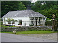
The Lodge
Gatehouse to the Maesgwynne estate. The nearer part is genuinely round, unlike the octagonal "round" gatehouse shown in Image
Image: © Roger W Haworth
Taken: 7 Jun 2007
0.18 miles
2
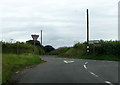
Road junction west of Llanboidy
Turn left for Llanfallteg and right for Llanglydwen.
Image: © Peter Kazmierczak
Taken: 6 Aug 2013
0.24 miles
3
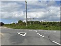
Crossroad near Llanboidy
The track opposite leads to the Maesgwynne estate.
Image: © Alan Hughes
Taken: 12 May 2020
0.25 miles