IMAGES TAKEN NEAR TO
Cwmbach, WHITLAND, SA34 0DR
Introduction
This page details the photographs taken nearby to SA34 0DR by members of the Geograph project.
The Geograph project started in 2005 with the aim of publishing, organising and preserving representative images for every square kilometre of Great Britain, Ireland and the Isle of Man.

There are currently over 7.5m images from over14,400 individuals and you can help contribute to the project by visiting https://www.geograph.org.uk
Image Map
Images are licensed for reuse under creativecommons.org/licenses/by-sa/2.0
Notes
- Clicking on the map will re-center to the selected point.
- The higher the marker number, the further away the image location is from the centre of the postcode.
Image Listing (4 Images Found)
Images are licensed for reuse under creativecommons.org/licenses/by-sa/2.0
Image
Details
Distance
1
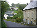
Cwmbach Primary School
(now closed) is on the right.
Image: © Roger W Haworth
Taken: 21 Sep 2007
0.10 miles
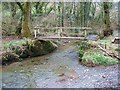
3
Llwybr Ceffyl Cwmbach Bridleway
Llwybr ceffyl ar y chwith yn gadael yr heol yng Nghwmbach.
A bridleway on the left leaving a minor road in Cwmbach (trans. small valley)
Image: © Alan Richards
Taken: 28 Sep 2008
0.15 miles
4
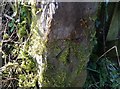
Ordnance Survey Cut Mark
This OS cut mark can be found on the gatepost west side of the road. It marks a point 140.878m above mean sea level.
Image: © Adrian Dust
Taken: 3 Mar 2020
0.21 miles