IMAGES TAKEN NEAR TO
Lime Kiln Lane, SWANSEA, SA3 3DH
Introduction
This page details the photographs taken nearby to Lime Kiln Lane, SA3 3DH by members of the Geograph project.
The Geograph project started in 2005 with the aim of publishing, organising and preserving representative images for every square kilometre of Great Britain, Ireland and the Isle of Man.

There are currently over 7.5m images from over14,400 individuals and you can help contribute to the project by visiting https://www.geograph.org.uk
Image Map (Loading...)


Getting Data...Please wait
Leaflet Map data © OpenStreetMap
Images are licensed for reuse under creativecommons.org/licenses/by-sa/2.0
Notes
- Clicking on the map will re-center to the selected point.
- The higher the marker number, the further away the image location is from the centre of the postcode.
Image Listing (32 Images Found)
Images are licensed for reuse under creativecommons.org/licenses/by-sa/2.0
Image
Details
Distance
1
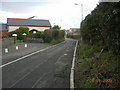
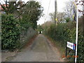
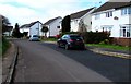
Lime Kiln Lane
A narrow lane which now links the main road with a housing estate around the back.
Image: © Julian Evans
Taken: 5 Jan 2009
0.02 miles
2
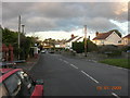
Oldway, Bishopston
The roads in Bishopston keep changing in width, this is the last wide bit on the way out to Murton, part of a small triangle of grass is on the right.
Image: © Julian Evans
Taken: 5 Jan 2009
0.13 miles
3
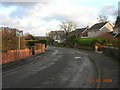
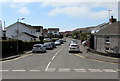
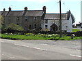
Back of Bishopston
A fairly typical road of houses in Bishopston with a curious road sign
Image: © Julian Evans
Taken: 5 Jan 2009
0.16 miles
4
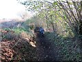
Llwybr Ceffyl Oldway Bridleway
Llwybr Ceffyl yn Oldway sy'n arwain i gyfeiriad Manselfield
A bridleway in Oldway going in the direction of Manselfield.
Image: © Alan Richards
Taken: 24 Nov 2013
0.17 miles
5
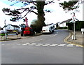
Ridley Way...
This little lane is off the junction between Pyle Road and Caswell Bay road and becomes a path which leads to Bishopston comprehensive school.
Image: © Julian Evans
Taken: 5 Jan 2009
0.17 miles
6
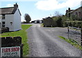
Access road to Murton Farm Shop
From Manselfield Road in Murton.
Image: © Jaggery
Taken: 19 Apr 2018
0.19 miles
7
On-street parking, Tudor Way, Murton
Viewed across Manselfield Road in April 2018.
Image: © Jaggery
Taken: 19 Apr 2018
0.21 miles
8
Junction of Oldway and Eastlands Park, Murton
Viewed across Oldway. Signs show no motor vehicles in Eastlands Park except for access.
Image: © Jaggery
Taken: 19 Apr 2018
0.22 miles
9
White houses, Eastlands Park, Murton
In the southern part of Eastlands Park, an area of houses on the west side of Oldway.
Image: © Jaggery
Taken: 19 Apr 2018
0.22 miles
10
Manselfield Road houses, Murton
Set back from the south side of Manselfield Road.
Image: © Jaggery
Taken: 19 Apr 2018
0.22 miles