IMAGES TAKEN NEAR TO
Whitestone Road, SWANSEA, SA3 3DB
Introduction
This page details the photographs taken nearby to Whitestone Road, SA3 3DB by members of the Geograph project.
The Geograph project started in 2005 with the aim of publishing, organising and preserving representative images for every square kilometre of Great Britain, Ireland and the Isle of Man.

There are currently over 7.5m images from over14,400 individuals and you can help contribute to the project by visiting https://www.geograph.org.uk
Image Map
Images are licensed for reuse under creativecommons.org/licenses/by-sa/2.0
Notes
- Clicking on the map will re-center to the selected point.
- The higher the marker number, the further away the image location is from the centre of the postcode.
Image Listing (11 Images Found)
Images are licensed for reuse under creativecommons.org/licenses/by-sa/2.0
Image
Details
Distance
1
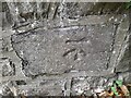
Ordnance Survey Cut Mark
This OS cut mark can be found on the wall of No23 Caswell Bay Road. It marks a point 72.052m above mean sea level.
Image: © Adrian Dust
Taken: 26 Oct 2022
0.08 miles
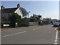
2
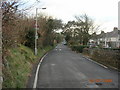
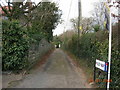
Road towards Caswell
The long, straight, humpy road out of Bishopston village that becomes rural and shortly drops down to Caswell spectacularly.
Image: © Julian Evans
Taken: 5 Jan 2009
0.09 miles
3
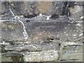
Ordnance Survey Cut Mark
This OS cut mark can be found on the wall south side of Pyle Road. It marks a point 74.493m above mean sea level.
Image: © Adrian Dust
Taken: 26 Oct 2022
0.14 miles
5
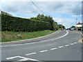
Brandy Cove Road
Brandy Cove Road, Bishopston.
Image: © Alan Hughes
Taken: 1 Apr 2019
0.16 miles
6
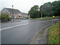
Pyle Corner, Bishopston
Bishopston Road turning right, lane to Pwlldu Bay ahead, lane to Brandy Cove to left of Post Office.
Image: © Jennifer Luther Thomas
Taken: 25 Aug 2006
0.19 miles
7
Hareslade, Gower
Timber-clad chalets at Hareslade, Gower
Image: © Alan Hughes
Taken: 16 Dec 2015
0.20 miles
8
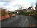
Back of Bishopston
A fairly typical road of houses in Bishopston with a curious road sign
Image: © Julian Evans
Taken: 5 Jan 2009
0.22 miles
9
Ridley Way...
This little lane is off the junction between Pyle Road and Caswell Bay road and becomes a path which leads to Bishopston comprehensive school.
Image: © Julian Evans
Taken: 5 Jan 2009
0.22 miles
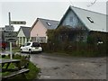
10
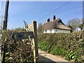
Tracks to Pwlldu and Southgate
Track junction and thatched house.
Image: © Alan Hughes
Taken: 1 Apr 2019
0.24 miles