IMAGES TAKEN NEAR TO
Cynwyl Elfed, CARMARTHEN, SA33 6ST
Introduction
This page details the photographs taken nearby to SA33 6ST by members of the Geograph project.
The Geograph project started in 2005 with the aim of publishing, organising and preserving representative images for every square kilometre of Great Britain, Ireland and the Isle of Man.

There are currently over 7.5m images from over14,400 individuals and you can help contribute to the project by visiting https://www.geograph.org.uk
Image Map (Loading...)


Getting Data...Please wait
Leaflet Map data © OpenStreetMap
Images are licensed for reuse under creativecommons.org/licenses/by-sa/2.0
Notes
- Clicking on the map will re-center to the selected point.
- The higher the marker number, the further away the image location is from the centre of the postcode.
Image Listing (2 Images Found)
Images are licensed for reuse under creativecommons.org/licenses/by-sa/2.0
Image
Details
Distance
1
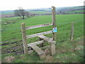
Dim Ffordd Drwodd / No Through Road
Dyma arwydd ' Dim Ffordd Drwodd' ar sticil ger Ffarm Clungwyn. Mae'r llwybr yn arwain at Ysgol Nantcwmrhys sy bellach yn adfail.
A 'No Through Road' sign on a stile near Clungwyn Farm (Trans. 'Fairmeadow'). The path itself leads down towards the now ruined Nantcwmrhys School (Trans. Rhys's Valley Stream).
Image: © Alan Richards
Taken: 27 Mar 2005
0.20 miles
2
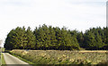
Woodland near Golden Grove, Cynwyl Elfed
Image: © Dylan Moore
Taken: 17 Mar 2009
0.21 miles