IMAGES TAKEN NEAR TO
Clos Y Cynin, CARMARTHEN, SA33 6QS
Introduction
This page details the photographs taken nearby to Clos Y Cynin, SA33 6QS by members of the Geograph project.
The Geograph project started in 2005 with the aim of publishing, organising and preserving representative images for every square kilometre of Great Britain, Ireland and the Isle of Man.

There are currently over 7.5m images from over14,400 individuals and you can help contribute to the project by visiting https://www.geograph.org.uk
Image Map (Loading...)


Getting Data...Please wait
Leaflet Map data © OpenStreetMap
Images are licensed for reuse under creativecommons.org/licenses/by-sa/2.0
Notes
- Clicking on the map will re-center to the selected point.
- The higher the marker number, the further away the image location is from the centre of the postcode.
Image Listing (15 Images Found)
Images are licensed for reuse under creativecommons.org/licenses/by-sa/2.0
Image
Details
Distance
1
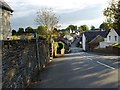
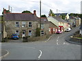
Rock Hall, Trelech, Trelech ar Betws
The part of the building on the right looks to have been a shop. It was the post office in the 1950s.
Image: © Humphrey Bolton
Taken: 30 Sep 2007
0.03 miles
2
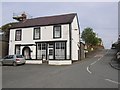
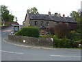
The road to Meidrim, Trelech, Trelech ar Betws
Taken from the road junction in the centre of the hamlet.
Image: © Humphrey Bolton
Taken: 30 Sep 2007
0.03 miles
3
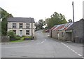
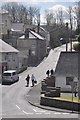
Looking south west out of Trelech
The roads do not seem to have names and from this point all three roads go uphill.
Image: © Roger W Haworth
Taken: 20 Sep 2007
0.03 miles
4
Cottages in Trelech
The other side of the road from Image The roads do not seem to have names.
Image: © Roger W Haworth
Taken: 20 Sep 2007
0.04 miles
5
Trelech : Village Road
A road heading up the hillside in Trelech.
Image: © Lewis Clarke
Taken: 11 Apr 2014
0.04 miles
6
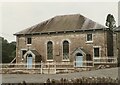
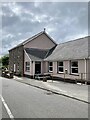
Capel y Graig, Welsh Independent Chapel, Trelech
The first meeting house on this site was built in 1703. Prior to that from 1670 meetings were in local farms.
The two arched windows have 20th century coloured lead glass.
There were several stages of rebuilding, in particular in 1791, 1801 and 1827 during the time of Morgan Jones the then minister. It is recorded that at times the chapel was so full that the minister had to preach to the congregation through a chapel window. In 1829 there were 556 members added to the church. Each month the new members were welcomed personally by the minister in ‘giving the right hand of fellowship’. In May of that year 110 were welcome with the queue emerging from one of the doors and in a large circle around the front of the chapel and back through the other door.
Image: © Robin Drayton
Taken: 1 Jan 1987
0.05 miles

8
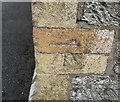
Ordnance Survey Cut Mark
This OS cut mark can be found on the front of the school. It marks a point 188.577m above mean sea level.
Image: © Adrian Dust
Taken: 20 Sep 2016
0.07 miles