IMAGES TAKEN NEAR TO
Penybont, CARMARTHEN, SA33 6PJ
Introduction
This page details the photographs taken nearby to SA33 6PJ by members of the Geograph project.
The Geograph project started in 2005 with the aim of publishing, organising and preserving representative images for every square kilometre of Great Britain, Ireland and the Isle of Man.

There are currently over 7.5m images from over14,400 individuals and you can help contribute to the project by visiting https://www.geograph.org.uk
Image Map
Images are licensed for reuse under creativecommons.org/licenses/by-sa/2.0
Notes
- Clicking on the map will re-center to the selected point.
- The higher the marker number, the further away the image location is from the centre of the postcode.
Image Listing (9 Images Found)
Images are licensed for reuse under creativecommons.org/licenses/by-sa/2.0
Image
Details
Distance
1
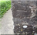
Ordnance Survey Cut Mark
This OS cut mark can be found on the north face of St Teilo's Church. It marks a point 175.214m above mean sea level.
Image: © Adrian Dust
Taken: 20 Sep 2016
0.02 miles
3
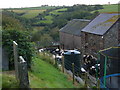
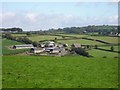
Milking time
We are looking from the churchyard of St. Teilo, Trelech a'r Betws, across one of the deep valleys typical of this area. The farm in the distance is called Breunant.
Image: © Roger W Haworth
Taken: 17 Sep 2007
0.07 miles
4
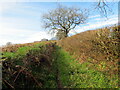
Llwybr i Eglwys Trelech a'r Betws / Path to Trelech a'r Betws Church
Llwybr yn mynd i gyfeiriad Eglwys Blwyfol Trelech a'r Betws.
A path heads in the direction of Trelech a'r Betws Parish Church.
Image: © Alan Richards
Taken: 13 Apr 2023
0.07 miles
5
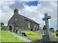
Trelech-a'r-Bettws
St Teilo's Church, to the right of centre.
Image: © Emrys Harries
Taken: 10 Sep 2007
0.09 miles
6
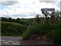
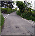
Road sign at crossroad
Crossroad near Trelech-a'r-Bettws
Image: © John Duckfield
Taken: 21 May 2009
0.09 miles
7
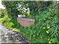
Churn Stand
There is an Ordnance Survey rivet on the top of the stand. https://www.geograph.org.uk/photo/7466933
Image: © Adrian Dust
Taken: 26 Apr 2023
0.10 miles
8
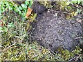
Ordnance Survey Rivet
This OS rivet can be found on the top of the churn stand. It marks a point 174.150m above mean sea level. https://www.geograph.org.uk/photo/7466931
Image: © Adrian Dust
Taken: 26 Apr 2023
0.10 miles
9
Cross roads .
Maesteilo on the right, Vicaridge on the left.
Image: © John Duckfield
Taken: 21 May 2009
0.11 miles