IMAGES TAKEN NEAR TO
Llanpumsaint, CARMARTHEN, SA33 6LR
Introduction
This page details the photographs taken nearby to SA33 6LR by members of the Geograph project.
The Geograph project started in 2005 with the aim of publishing, organising and preserving representative images for every square kilometre of Great Britain, Ireland and the Isle of Man.

There are currently over 7.5m images from over14,400 individuals and you can help contribute to the project by visiting https://www.geograph.org.uk
Image Map
Images are licensed for reuse under creativecommons.org/licenses/by-sa/2.0
Notes
- Clicking on the map will re-center to the selected point.
- The higher the marker number, the further away the image location is from the centre of the postcode.
Image Listing (1 Images Found)
Images are licensed for reuse under creativecommons.org/licenses/by-sa/2.0
Image
Details
Distance
1
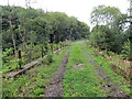
Hen bont reilffordd / Disused railway bridge
Pont hen reilffordd yn rhychwantu Afon Gwili. Dyma hen lein Caerfyrddin i Aberystwyth a gaewyd dan bwyell anenwog Beeching yn 1965 - twpdra o'r radd flaenaf. Mae'r trac yn eiddo i Reilffordd Gwili a'r gobaith yw ehangu'r line mor bell â Llanpumsaint yn y dyfodol.
A disused railway bridge spans Afon Gwili. This was the Carmarthen-Aberystwyth line which closed in 1965 by the infamous Beeching axe - an act of utter stupidity! The track belongs to the Gwili Railway and it hopes to extend the line as far as Llanpumsaint in the future.
Image: © Alan Richards
Taken: 19 Aug 2023
0.16 miles