IMAGES TAKEN NEAR TO
Llanpumsaint, CARMARTHEN, SA33 6JU
Introduction
This page details the photographs taken nearby to SA33 6JU by members of the Geograph project.
The Geograph project started in 2005 with the aim of publishing, organising and preserving representative images for every square kilometre of Great Britain, Ireland and the Isle of Man.

There are currently over 7.5m images from over14,400 individuals and you can help contribute to the project by visiting https://www.geograph.org.uk
Image Map (Loading...)


Getting Data...Please wait
Leaflet Map data © OpenStreetMap
Images are licensed for reuse under creativecommons.org/licenses/by-sa/2.0
Notes
- Clicking on the map will re-center to the selected point.
- The higher the marker number, the further away the image location is from the centre of the postcode.
Image Listing (5 Images Found)
Images are licensed for reuse under creativecommons.org/licenses/by-sa/2.0
Image
Details
Distance
3

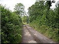
The road down from Esgair
Steep and uneven, this narrow lane certainly warrants the visible grit bin.
Image: © Nigel Davies
Taken: 1 Jan 2009
0.11 miles
4
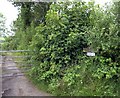
Country road above Esgair
Council maintained just about
Image: © John Duckfield
Taken: 3 Jul 2009
0.12 miles
5

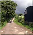
Pen yr Esgair
Llwybr cyhoeddus yn agosau at safle Ffarm Pen yr Esgair. Sied amaethyddol fodern sy yno bellach.
A public footpath approaching the site of the former Pen yr Esgair Farm (trans. top of the ridge). The site is now occupied by a modern agricultural shed.
Image: © Alan Richards
Taken: 16 Jun 2015
0.24 miles