IMAGES TAKEN NEAR TO
Llanpumsaint, CARMARTHEN, SA33 6JP
Introduction
This page details the photographs taken nearby to SA33 6JP by members of the Geograph project.
The Geograph project started in 2005 with the aim of publishing, organising and preserving representative images for every square kilometre of Great Britain, Ireland and the Isle of Man.

There are currently over 7.5m images from over14,400 individuals and you can help contribute to the project by visiting https://www.geograph.org.uk
Image Map
Images are licensed for reuse under creativecommons.org/licenses/by-sa/2.0
Notes
- Clicking on the map will re-center to the selected point.
- The higher the marker number, the further away the image location is from the centre of the postcode.
Image Listing (4 Images Found)
Images are licensed for reuse under creativecommons.org/licenses/by-sa/2.0
Image
Details
Distance
1
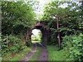
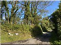
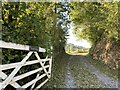
Llwybr Pantydriw Path
Llwybr cyhoeddus a thrac yn mynd o dan bont a arferai gludo Rheilffordd Caerfyrddin i Aberystwyth. Caewyd y lein gan yr anenwog y Ddr Beeching yn 1965. Mae 'na obeithion y bydd hi'n cael ei hailagor.
A public footpath and a track approaching a bridge which formerly carried the Carmarthen to Aberystwyth Railway line. Closed in 1965 by the infamous Dr Beeching there are hopes that the line will reopen.
Image: © Alan Richards
Taken: 29 Jul 2015
0.09 miles
2
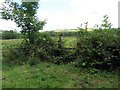
Llwybr Pantydriw Path
Sticil ar lwybr cyhoeddus ger Ffarm Pantydriw.
A stile on a public footpath near Pantydriw Farm (trans. druids'? hollow)
Image: © Alan Richards
Taken: 29 Jul 2015
0.11 miles