IMAGES TAKEN NEAR TO
Bronwydd Arms, CARMARTHEN, SA33 6HU
Introduction
This page details the photographs taken nearby to SA33 6HU by members of the Geograph project.
The Geograph project started in 2005 with the aim of publishing, organising and preserving representative images for every square kilometre of Great Britain, Ireland and the Isle of Man.

There are currently over 7.5m images from over14,400 individuals and you can help contribute to the project by visiting https://www.geograph.org.uk
Image Map (Loading...)


Getting Data...Please wait
Leaflet Map data © OpenStreetMap
Images are licensed for reuse under creativecommons.org/licenses/by-sa/2.0
Notes
- Clicking on the map will re-center to the selected point.
- The higher the marker number, the further away the image location is from the centre of the postcode.
Image Listing (18 Images Found)
Images are licensed for reuse under creativecommons.org/licenses/by-sa/2.0
Image
Details
Distance
1
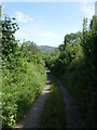
Lon rhwng/Lane between Penybanc & Ffynnon Wiber, Bronwydd Arms
Image: © David Jones
Taken: 18 Jun 2021
0.02 miles
2
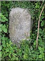
Old Milestone by the A484, south of Bronwydd
Stone post by the A484, in parish of Bronwydd (Carmarthenshire District), South of the former Bronwydd Arms public house.
Inscription reads:-
From
Carmarthen
2 Miles
To
Newcastle
17 Miles
Grade II listed by Cadw.
Reference Number: 81307 https://cadwpublic-api.azurewebsites.net/reports/listedbuilding/FullReport?lang=&id=81307
Surveyed
Milestone Society National ID: CAM_CMCA02
Image: © Milestone Society
Taken: Unknown
0.05 miles
3
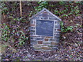
The Bronwydd Arms public house
Commemorative plaque for the demolished Bronwydd Arms public house and a shop, for road improvements in 1981. The location is still known as Bronwydd Arms despite there being no pub. seeImage for plate enlarged.
Image: © chris whitehouse
Taken: 14 Dec 2012
0.10 miles
4
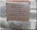
Bronwydd Arms commemorative plaque
Detail of the plate on the road side commemorative plaque.
Image: © chris whitehouse
Taken: 14 Dec 2012
0.10 miles
5
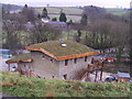
Mowable roof material
This building has turf on the roof, getting very popular as long as there is safe access and the pitch is not too great for slipping on the grass, new meaning to "keep of the grass"
Image: © chris whitehouse
Taken: 14 Dec 2012
0.10 miles
6
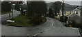
A484 junction at Bronwydd
Junction on A484 with B4301 road to Bronwydd Station (centre) on the Gwili Steam Railway. Road on right goes to Factory! and Peniel
Image: © chris whitehouse
Taken: 14 Dec 2012
0.13 miles
8
The line to Carmarthen
The extension south from Browydd Arms on the Gwili Railway. Track is in situ to Abergwili Junction station on the northern outskirts of Carmarthen and a run round loop has been constructed there. The station lies immediately behind Glan Gwili Hospital. Current information suggests that the extension will be opened at some time in 2017. The 'jewel in the crown' would be to extend the line to connect with the network at Carmarthen station but I know not if this is proposed or, indeed, feasible.
Image: © John Lucas
Taken: 26 Apr 2017
0.14 miles
9
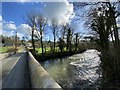
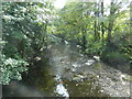
Afon Gwili
Road bridge over Afon Gwili.
Image: © Alan Hughes
Taken: 27 Feb 2020
0.15 miles
10
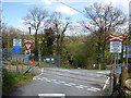
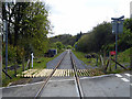
Open level crossing at Bronwydd
The crossing is not protected by gates or barriers. The line is crossed by a minor road from Bronwydd to Peniel. It is on the Gwili Railway's extension to northern Carmarthen which is expected to open in 2017. Level crossings are an acknowledged railway hazard and although I don't know the conditions imposed by the Railway Inspectorate, I suspect that, at a minimum, a flagman will need to control the crossing when the extension is operational.
Afternote: I have been informed by a member of the Gwili Railway that under the terms of its light railway order, a flagman will not be required at the crossing but that trains will need to slow to 5 mph.
Image: © John Lucas
Taken: 26 Apr 2017
0.15 miles