IMAGES TAKEN NEAR TO
Blaenycoed Road, CARMARTHEN, SA33 6EP
Introduction
This page details the photographs taken nearby to Blaenycoed Road, SA33 6EP by members of the Geograph project.
The Geograph project started in 2005 with the aim of publishing, organising and preserving representative images for every square kilometre of Great Britain, Ireland and the Isle of Man.

There are currently over 7.5m images from over14,400 individuals and you can help contribute to the project by visiting https://www.geograph.org.uk
Image Map (Loading...)


Getting Data...Please wait
Leaflet Map data © OpenStreetMap
Images are licensed for reuse under creativecommons.org/licenses/by-sa/2.0
Notes
- Clicking on the map will re-center to the selected point.
- The higher the marker number, the further away the image location is from the centre of the postcode.
Image Listing (7 Images Found)
Images are licensed for reuse under creativecommons.org/licenses/by-sa/2.0
Image
Details
Distance
1
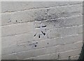
Ordnance Survey Cut Mark
This OS cut mark can be found on the outbuilding at Pen Rhiw Crynfryn. It marks a point 206.114m above mean sea level.
Image: © Adrian Dust
Taken: 24 Oct 2019
0.01 miles
3
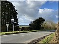
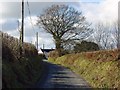
Sign post
Sign post on the Carmarthen to Cynwyl Elfed road.
Image: © Alan Hughes
Taken: 27 Feb 2020
0.02 miles
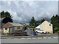
5
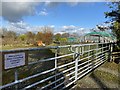
Maes y Gwenyn
Gateway to farm at Maes y Gwenyn.
Image: © Alan Hughes
Taken: 27 Feb 2020
0.05 miles
6
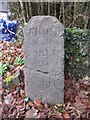
Old Milestone off the A484, Bwlchnewydd, Cynwyl Elfed Parish
South west of the A484, in parish of Cynwyl Elfed (Carmarthenshire District), Pen-rhiw-crynfryn, North of Bwlchnewydd.
Inscription reads:-
FROM
CARMARTHEN
5 MILES
TO
NEWCASTLE
14 MILES
Grade II listed by Cadw. Reference Number: 23987
https://cadwpublic-api.azurewebsites.net/reports/listedbuilding/FullReport?lang=&id=23987
Surveyed
Milestone Society National ID: CAM_CMCA05.
Image: © Milestone Society
Taken: 1 Jan 2011
0.08 miles