IMAGES TAKEN NEAR TO
Henfwlch Road, CARMARTHEN, SA33 6AQ
Introduction
This page details the photographs taken nearby to Henfwlch Road, SA33 6AQ by members of the Geograph project.
The Geograph project started in 2005 with the aim of publishing, organising and preserving representative images for every square kilometre of Great Britain, Ireland and the Isle of Man.

There are currently over 7.5m images from over14,400 individuals and you can help contribute to the project by visiting https://www.geograph.org.uk
Image Map
Images are licensed for reuse under creativecommons.org/licenses/by-sa/2.0
Notes
- Clicking on the map will re-center to the selected point.
- The higher the marker number, the further away the image location is from the centre of the postcode.
Image Listing (2 Images Found)
Images are licensed for reuse under creativecommons.org/licenses/by-sa/2.0
Image
Details
Distance
1
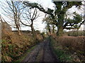
Heol ddiwyneb ger Tynewydd/ Unsurfaced road near Tynewydd
Heol ddiwyneb ger anhedd-dy o'r enw Tynewydd.
A unsurfaced road near a property known as Tynewydd (trans. new house).
Image: © Alan Richards
Taken: 26 Jan 2023
0.03 miles
2
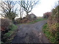
Cyffordd o draciau / A junction of tracks
Cyffordd o draciau ger anhedd-dy o'r enw Tynewydd.
A junction of tracks near a property known as Tynewydd (trans. new house).
Image: © Alan Richards
Taken: 26 Jan 2023
0.14 miles