IMAGES TAKEN NEAR TO
Henfwlch Road, CARMARTHEN, SA33 6AF
Introduction
This page details the photographs taken nearby to Henfwlch Road, SA33 6AF by members of the Geograph project.
The Geograph project started in 2005 with the aim of publishing, organising and preserving representative images for every square kilometre of Great Britain, Ireland and the Isle of Man.

There are currently over 7.5m images from over14,400 individuals and you can help contribute to the project by visiting https://www.geograph.org.uk
Image Map
Images are licensed for reuse under creativecommons.org/licenses/by-sa/2.0
Notes
- Clicking on the map will re-center to the selected point.
- The higher the marker number, the further away the image location is from the centre of the postcode.
Image Listing (4 Images Found)
Images are licensed for reuse under creativecommons.org/licenses/by-sa/2.0
Image
Details
Distance
1
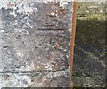
Ordnance Survey Cut Mark
This OS cut mark can be found on the NW angle of the St Michael's Church. It marks a point 189.082m above mean sea level.
Image: © Adrian Dust
Taken: 24 Oct 2019
0.03 miles
2
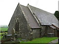
12th century "new church" at Llannewydd/Newchurch
(From a display board opposite the church.) "As early as the 12th century AD, Newchurch was known as Eglwys Newydd. This suggests that the present parish church was a Norman foundation replacing an earlier Celtic church, quite possibly that of Llanfihangel Crosfeint which was demolished in 1847. The parish of Newchurch was held and valued by Carmarthen Priory in the Middle Ages. At one time the Prior lived at Carmarthen Castle, and, as a result, the area inside the castle walls was made a part of Newchurch parish."The church is dedicated to Sant Mihangel/Saint Michael.
Image: © Colin Bell
Taken: 18 Jun 2008
0.05 miles
3
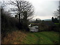
Llwybr Ty'r Eglwys Path
Llwybr ceffyl yn agosau at Ffarm Ty'r Eglwys.
Bridleway approaching Ty'r Eglwys Farm (trans. church house).
Image: © Alan Richards
Taken: 15 Jan 2005
0.14 miles
4
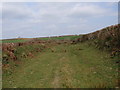
Llwybr Ceffyl Ty'r Eglwys bridleway
Llwybr ceffyl dymunol gerllaw Ffarm Ty'r Eglwys, Llannewydd.
A fine bridleway near Ty'r Eglwys Farm (trans. Church House), Newchurch.
Image: © Alan Richards
Taken: 1 Apr 2012
0.20 miles