IMAGES TAKEN NEAR TO
Abernant, CARMARTHEN, SA33 5RP
Introduction
This page details the photographs taken nearby to SA33 5RP by members of the Geograph project.
The Geograph project started in 2005 with the aim of publishing, organising and preserving representative images for every square kilometre of Great Britain, Ireland and the Isle of Man.

There are currently over 7.5m images from over14,400 individuals and you can help contribute to the project by visiting https://www.geograph.org.uk
Image Map (Loading...)


Getting Data...Please wait
Leaflet Map data © OpenStreetMap
Images are licensed for reuse under creativecommons.org/licenses/by-sa/2.0
Notes
- Clicking on the map will re-center to the selected point.
- The higher the marker number, the further away the image location is from the centre of the postcode.
Image Listing (4 Images Found)
Images are licensed for reuse under creativecommons.org/licenses/by-sa/2.0
Image
Details
Distance
2

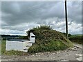
Extraordinarily smelly farm entrance
The road surface here was liberally spread with manure (as can be seen), and this was accompanied by an almost overpowering smell. Fortunately (for you) Geograph only preserves visuals.
Image: © Colin Bell
Taken: 18 Jun 2008
0.12 miles
4
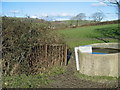
Llwybr Posty Uchaf / Posty Uchaf Path
Hen gât fochyn ar lwybr cyhoeddus ger Ffarm Posty Uchaf sy wedi'i hen esgeuluso'n gan y cyngor cymunedol lleol a'r cyngor sir sy'n gyndyn iawn i'w ailagor.
Old kissing gate on a long neglected path leading to Posty Uchaf Farm. Despite complaining to the local community council and county council nothing seems to get done!
Image: © Alan Richards
Taken: 15 Feb 2005
0.17 miles