IMAGES TAKEN NEAR TO
Meidrim, CARMARTHEN, SA33 5PQ
Introduction
This page details the photographs taken nearby to SA33 5PQ by members of the Geograph project.
The Geograph project started in 2005 with the aim of publishing, organising and preserving representative images for every square kilometre of Great Britain, Ireland and the Isle of Man.

There are currently over 7.5m images from over14,400 individuals and you can help contribute to the project by visiting https://www.geograph.org.uk
Image Map
Images are licensed for reuse under creativecommons.org/licenses/by-sa/2.0
Notes
- Clicking on the map will re-center to the selected point.
- The higher the marker number, the further away the image location is from the centre of the postcode.
Image Listing (3 Images Found)
Images are licensed for reuse under creativecommons.org/licenses/by-sa/2.0
Image
Details
Distance
1
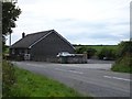
Blaenwaun
Cottage on the road between Meidrim and Trelech. Lane to the right goes to Penygraig.
Image: © Emrys Harries
Taken: 4 Aug 2006
0.03 miles
3
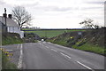
Carmarthenshire : The B4299
A road heading through the Carmarthenshire countryside.
Image: © Lewis Clarke
Taken: 11 Apr 2014
0.18 miles