IMAGES TAKEN NEAR TO
Lon Cowin, CARMARTHEN, SA33 5NF
Introduction
This page details the photographs taken nearby to Lon Cowin, SA33 5NF by members of the Geograph project.
The Geograph project started in 2005 with the aim of publishing, organising and preserving representative images for every square kilometre of Great Britain, Ireland and the Isle of Man.

There are currently over 7.5m images from over14,400 individuals and you can help contribute to the project by visiting https://www.geograph.org.uk
Image Map (Loading...)


Getting Data...Please wait
Leaflet Map data © OpenStreetMap
Images are licensed for reuse under creativecommons.org/licenses/by-sa/2.0
Notes
- Clicking on the map will re-center to the selected point.
- The higher the marker number, the further away the image location is from the centre of the postcode.
Image Listing (39 Images Found)
Images are licensed for reuse under creativecommons.org/licenses/by-sa/2.0
Image
Details
Distance
1
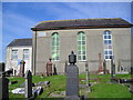
Capel Bankyfelin
Built in 1788 and spelled with a "K" on the wall plaque.
Image: © Marion Phillips
Taken: 2 Sep 2010
0.04 miles
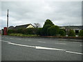
2
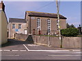
Chapel at Bancyfelin
Chapel stands on the cross roads with the old A40 in the village.
Image: © chris whitehouse
Taken: 2 Mar 2012
0.07 miles
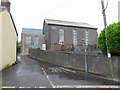
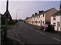
4
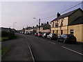
The old main road, Bancyfelin, St Clears
This was the A40, but the hamlet is now bypassed.
Image: © Humphrey Bolton
Taken: 26 Oct 2016
0.07 miles
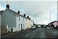
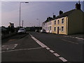
5
Bancyfelin old A40 road
These older houses are just about in SN3217, maybe the red car is parked in SN3218.
Image: © chris whitehouse
Taken: 2 Mar 2012
0.07 miles
6
Red Telephone Box, Bancyfelin
A red telephone box beside the former A40 trunk road at Bancyfelin.
Image: © Martyn Harries
Taken: 21 Nov 2010
0.08 miles
7
Old A40 road Bancyfelin
Hard to believe this road was the major route through this village from Carmarthen to St. Clears, Whitland and Haverfordwest.
Image: © chris whitehouse
Taken: 2 Mar 2012
0.09 miles
8
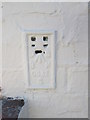
Ordnance Survey Flush Bracket (S0632)
This OS Flush Bracket can be found on the front of Crown House. It marks a point 19.975m above mean sea level.
Image: © Adrian Dust
Taken: 6 Jul 2014
0.09 miles
9
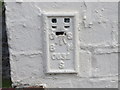
Ordnance Survey Flush Bracket S0632
This can be found on the wall of Crown House.
Image: © Peter Wood
Taken: 23 May 2013
0.09 miles
10
Fox and Hounds Bancyfelin
Popular watering hole in this area.
Image: © chris whitehouse
Taken: 2 Mar 2012
0.10 miles