IMAGES TAKEN NEAR TO
Llansteffan, CARMARTHEN, SA33 5JH
Introduction
This page details the photographs taken nearby to SA33 5JH by members of the Geograph project.
The Geograph project started in 2005 with the aim of publishing, organising and preserving representative images for every square kilometre of Great Britain, Ireland and the Isle of Man.

There are currently over 7.5m images from over14,400 individuals and you can help contribute to the project by visiting https://www.geograph.org.uk
Image Map
Images are licensed for reuse under creativecommons.org/licenses/by-sa/2.0
Notes
- Clicking on the map will re-center to the selected point.
- The higher the marker number, the further away the image location is from the centre of the postcode.
Image Listing (70 Images Found)
Images are licensed for reuse under creativecommons.org/licenses/by-sa/2.0
Image
Details
Distance
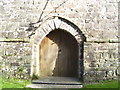
1
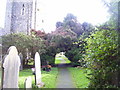
Archway over path - St Stephen's Church, Llanstephan
Image: © welshbabe
Taken: 20 Nov 2015
0.01 miles
2
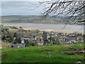
Overlooking Llansteffan
From the west, looking across the River Towy.
Image: © Robin Drayton
Taken: 23 Mar 2009
0.01 miles
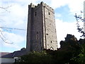
3
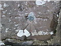
Ordnance Survey 1GL Bolt
This OS Bolt can be found on the north face of the tower of St Stephen's Church. It marks a point 25.1233m above mean sea level.
Image: © Adrian Dust
Taken: 10 Jan 2015
0.02 miles
4
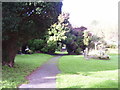
Path in Churchyard of St Stephens, Llanstepahn
Image: © welshbabe
Taken: 20 Nov 2015
0.02 miles
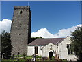
9
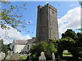
Church of St Ysteffan, Llansteffan
The church was founded in the 6th century.
Image: © Richard Rogerson
Taken: 10 Aug 2014
0.03 miles
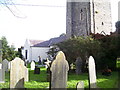
10
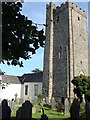
Llansteffan church - tower and east end of churchyard
Image: © Ruth Sharville
Taken: 7 Aug 2009
0.03 miles