IMAGES TAKEN NEAR TO
Llanybri, CARMARTHEN, SA33 5HN
Introduction
This page details the photographs taken nearby to SA33 5HN by members of the Geograph project.
The Geograph project started in 2005 with the aim of publishing, organising and preserving representative images for every square kilometre of Great Britain, Ireland and the Isle of Man.

There are currently over 7.5m images from over14,400 individuals and you can help contribute to the project by visiting https://www.geograph.org.uk
Image Map
Images are licensed for reuse under creativecommons.org/licenses/by-sa/2.0
Notes
- Clicking on the map will re-center to the selected point.
- The higher the marker number, the further away the image location is from the centre of the postcode.
Image Listing (5 Images Found)
Images are licensed for reuse under creativecommons.org/licenses/by-sa/2.0
Image
Details
Distance
1
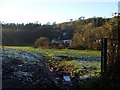
Coomb Mill and Hendre Lodge
Coombe Mill farm in the centre with Hendre Lodge on the hillside and Coed Hendre (woods) to the left on a frosty December afternoon.
Image: © Peter Shaw
Taken: 28 Dec 2008
0.01 miles
2
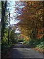
Lane towards Coomb Mill
Lane towards Coomb Mill (farm) with Coed Hendre (Hendre Woods) just visible in the distance.
Image: © Peter Shaw
Taken: 13 Nov 2008
0.07 miles
4
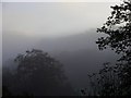
Frosty morning
Morning sunlight shines on trees which border a country lane whilst the frost still remains on the shaded hillside.
Image: © Peter Shaw
Taken: 14 Dec 2008
0.19 miles
5
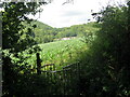
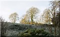
Llwybr i Felin y Cwm / Path to Coomb Mill
Llwybr troed cyhoeddus yn mynd i gyfeiriad Melin y Cwm.
A public footpath heads in the direction of Coomb Mill < cwm (valley).
Image: © Alan Richards
Taken: 17 Jul 2023
0.20 miles