IMAGES TAKEN NEAR TO
Llysonnen Road, CARMARTHEN, SA33 5DY
Introduction
This page details the photographs taken nearby to Llysonnen Road, SA33 5DY by members of the Geograph project.
The Geograph project started in 2005 with the aim of publishing, organising and preserving representative images for every square kilometre of Great Britain, Ireland and the Isle of Man.

There are currently over 7.5m images from over14,400 individuals and you can help contribute to the project by visiting https://www.geograph.org.uk
Image Map
Images are licensed for reuse under creativecommons.org/licenses/by-sa/2.0
Notes
- Clicking on the map will re-center to the selected point.
- The higher the marker number, the further away the image location is from the centre of the postcode.
Image Listing (5 Images Found)
Images are licensed for reuse under creativecommons.org/licenses/by-sa/2.0
Image
Details
Distance
1
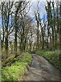
Tro yn yr heol / Bend in the road
Tro yn yr heol ger Llys Newydd. Ar y dde mae llwybr cyhoeddus yn gadael yr heol.
A bend in the road near Llys Newydd (trans. new court). A public footpath exits the road on the right.
Image: © Alan Richards
Taken: 29 Dec 2022
0.15 miles
2
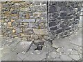
Ordnance Survey Cut Mark
This OS cut mark can be found on the roadside barn at Nantyrhebog. It marks a point 29.998m above mean sea level.
Image: © Adrian Dust
Taken: 10 Feb 2023
0.16 miles
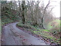
3
Llwybr ger Llys Newydd / Path near Llys Newydd
Llwybr cyhoeddus yn mynd drwy coedlan. Yn anffodus wrth ysgrifennu hyn mae'r llwybr wedi'i rwystro.
A public footpath heading through a copse. Unfortunately, at the time of writing the path is obstructed.
Image: © Alan Richards
Taken: 29 Dec 2022
0.16 miles
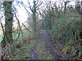
4
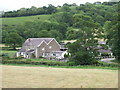
Nant yr hebog Farm
Back in the early 17th century, Nant yr hebog (Hawksbrook) estate was the home of John Prydderch who, as a contemporary of Galileo, made some of the very first telescopic astronomical observations.
See link:
http://brynjones.members.beeb.net/wastronhist/p_jprydderch.html
Image: © Gethin Evans
Taken: 26 May 2007
0.17 miles