IMAGES TAKEN NEAR TO
Llangynog, CARMARTHEN, SA33 5BZ
Introduction
This page details the photographs taken nearby to SA33 5BZ by members of the Geograph project.
The Geograph project started in 2005 with the aim of publishing, organising and preserving representative images for every square kilometre of Great Britain, Ireland and the Isle of Man.

There are currently over 7.5m images from over14,400 individuals and you can help contribute to the project by visiting https://www.geograph.org.uk
Image Map
Images are licensed for reuse under creativecommons.org/licenses/by-sa/2.0
Notes
- Clicking on the map will re-center to the selected point.
- The higher the marker number, the further away the image location is from the centre of the postcode.
Image Listing (6 Images Found)
Images are licensed for reuse under creativecommons.org/licenses/by-sa/2.0
Image
Details
Distance
1
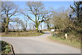
Road junction in Coedcae
Junction of country roads near Coedcae to the east of Bancyfelin.
Image: © Philip Halling
Taken: 6 Apr 2013
0.05 miles
3
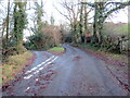
Cyffordd o heolydd bach / A junction of minor roads
Cyffordd o heolydd bach ger anhedd-dy o'r enw Felin-fach.
A junction of minor roads near a property known as Felin-fach (trans. small mill).
Image: © Alan Richards
Taken: 29 Dec 2022
0.09 miles
4
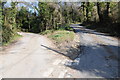
Junction of country roads
The junction of two minor country roads to the east of Bancyfelin.
Image: © Philip Halling
Taken: 6 Apr 2013
0.10 miles
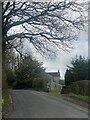
5

Ger Felin-fach - Near Felin-fach
Heol fach yn agosau at anhedd-dy o'r enw Felin-fach.
A minor road approaching a property known as Felin-fach (trans. small mill)
Image: © Alan Richards
Taken: 29 Dec 2022
0.14 miles
6
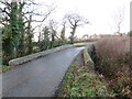
Pont dros Nant Coedcae / Bridge over Nant Coedcae
Pont yn rhychwantu Nant Coedcae.
A bridge spanning Nant Coedcae (trans. woodfield stream).
Image: © Alan Richards
Taken: 29 Dec 2022
0.17 miles