IMAGES TAKEN NEAR TO
Llangynog, CARMARTHEN, SA33 5BT
Introduction
This page details the photographs taken nearby to SA33 5BT by members of the Geograph project.
The Geograph project started in 2005 with the aim of publishing, organising and preserving representative images for every square kilometre of Great Britain, Ireland and the Isle of Man.

There are currently over 7.5m images from over14,400 individuals and you can help contribute to the project by visiting https://www.geograph.org.uk
Image Map
Images are licensed for reuse under creativecommons.org/licenses/by-sa/2.0
Notes
- Clicking on the map will re-center to the selected point.
- The higher the marker number, the further away the image location is from the centre of the postcode.
Image Listing (17 Images Found)
Images are licensed for reuse under creativecommons.org/licenses/by-sa/2.0
Image
Details
Distance
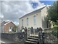
2
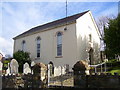
Ebenezer Baptist Chapel, Llangynog - built 1811
Image: © welshbabe
Taken: 12 Feb 2016
0.02 miles
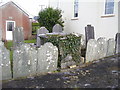
3
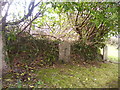
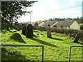
Ebenezer Baptist Chapel, Llangynog - graves
Image: © welshbabe
Taken: 12 Feb 2016
0.02 miles
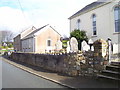
4
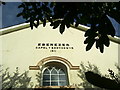
Capel Ebenezer, Llangynog
Non-conformist chapel.
Image: © Alan Hughes
Taken: 10 Apr 2023
0.02 miles
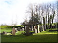
6
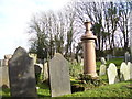
Ebenezer Baptist Chapel, Llangynog - graves
Image: © welshbabe
Taken: 12 Feb 2016
0.02 miles
7
Ebenezer Baptist Chapel, Llangynog - graves
Image: © welshbabe
Taken: 12 Feb 2016
0.02 miles
8
Ebenezer Baptist Chapel, Llangynog - graves
Image: © welshbabe
Taken: 12 Feb 2016
0.03 miles
9
Ebenezer Baptist Chapel, Llangynog - graves
Image: © welshbabe
Taken: 12 Feb 2016
0.03 miles