IMAGES TAKEN NEAR TO
Llangynog, CARMARTHEN, SA33 5BP
Introduction
This page details the photographs taken nearby to SA33 5BP by members of the Geograph project.
The Geograph project started in 2005 with the aim of publishing, organising and preserving representative images for every square kilometre of Great Britain, Ireland and the Isle of Man.

There are currently over 7.5m images from over14,400 individuals and you can help contribute to the project by visiting https://www.geograph.org.uk
Image Map
Images are licensed for reuse under creativecommons.org/licenses/by-sa/2.0
Notes
- Clicking on the map will re-center to the selected point.
- The higher the marker number, the further away the image location is from the centre of the postcode.
Image Listing (3 Images Found)
Images are licensed for reuse under creativecommons.org/licenses/by-sa/2.0
Image
Details
Distance
1
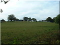
Parce Bach
That's the farm visible on the horizon.
Image: © David Medcalf
Taken: 2 Oct 2007
0.06 miles
2
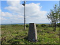
Ordnance Survey Trig Pillar S2370
This pillar can be found in a field near a reservoir to the south-west of Parce Bach.
Image: © Peter Wood
Taken: 25 May 2013
0.10 miles
3
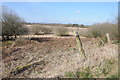
Rough grazing near Llangynog
Rough grazing and open access land near Llangynog.
Image: © Philip Halling
Taken: 6 Apr 2013
0.15 miles