IMAGES TAKEN NEAR TO
Llanmiloe, CARMARTHEN, SA33 4UA
Introduction
This page details the photographs taken nearby to SA33 4UA by members of the Geograph project.
The Geograph project started in 2005 with the aim of publishing, organising and preserving representative images for every square kilometre of Great Britain, Ireland and the Isle of Man.

There are currently over 7.5m images from over14,400 individuals and you can help contribute to the project by visiting https://www.geograph.org.uk
Image Map
Images are licensed for reuse under creativecommons.org/licenses/by-sa/2.0
Notes
- Clicking on the map will re-center to the selected point.
- The higher the marker number, the further away the image location is from the centre of the postcode.
Image Listing (5 Images Found)
Images are licensed for reuse under creativecommons.org/licenses/by-sa/2.0
Image
Details
Distance
2
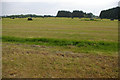
Silage all wrapped up
The building to the right is part of the Qinetiq complex.
Image: © Roger Gittins
Taken: 26 May 2010
0.06 miles
4
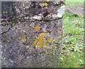
Ordnance Survey Cut Mark
This OS cut mark can be found on the west parapet of the bridge. It marks a point 5.224m above mean sea level.
Image: © Adrian Dust
Taken: 16 Dec 2021
0.21 miles