IMAGES TAKEN NEAR TO
Orchard Park Estate, CARMARTHEN, SA33 4TG
Introduction
This page details the photographs taken nearby to Orchard Park Estate, SA33 4TG by members of the Geograph project.
The Geograph project started in 2005 with the aim of publishing, organising and preserving representative images for every square kilometre of Great Britain, Ireland and the Isle of Man.

There are currently over 7.5m images from over14,400 individuals and you can help contribute to the project by visiting https://www.geograph.org.uk
Image Map
Images are licensed for reuse under creativecommons.org/licenses/by-sa/2.0
Notes
- Clicking on the map will re-center to the selected point.
- The higher the marker number, the further away the image location is from the centre of the postcode.
Image Listing (125 Images Found)
Images are licensed for reuse under creativecommons.org/licenses/by-sa/2.0
Image
Details
Distance
1

Stoneway Road, Laugharne
This appears to be the old road out of Laugharne to the south-west (note how it homes in on the market cross), later superseded by the present main road that reduces the gradient by curving round in a semi-circle. Stoneway road becomes an unsurfaced hollow-way further up, but the top end is now a housing estate road.
Image: © Humphrey Bolton
Taken: 2 Jul 2008
0.12 miles
2
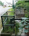
Trash grid, Water Street, Laugharne
This installation was presumably a response to a recurrent flooding problem. The vertical part of the grid will tend to become blocked with debris, so then the water level rises and the flow goes through the long horizontal grid.
Image: © Humphrey Bolton
Taken: 2 Jul 2008
0.13 miles
3
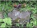
Trough, Water Street, Laugharne
Dated 1909. Now filled with earth, and someone has planted begonias to give a splash of colour.
Image: © Humphrey Bolton
Taken: 2 Jul 2008
0.13 miles
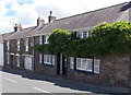
4
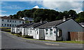
Frogmore Gardens bungalows, Laugharne
Viewed from Frogmore Street.
Image: © Jaggery
Taken: 21 Jul 2014
0.15 miles
5
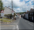
Warning signs in Laugharne
Two warning signs are on the corner of Gosport Street and Frogmore Gardens.
The one on the left shows that the road is liable to flooding. The sign on the right shows that Gosport Street narrows ahead. Oncoming vehicles may be in the middle of the road.
Image: © Jaggery
Taken: 21 Jul 2014
0.16 miles
6
Guest house in Gosport Street, Laugharne
There was no name visible here in July 2014 beyond a sign on the wall
showing B&B ensuite. Located opposite Frogmore Gardens.
Image: © Jaggery
Taken: 21 Jul 2014
0.16 miles
7

The Fountain Inn, Laugharne
The fountain no longer exists, but the market cross is still there in the middle of the road.
Image: © Humphrey Bolton
Taken: 29 Jun 2008
0.16 miles
8
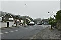
Laugharne: The A4066 running through the village
Image: © Michael Garlick
Taken: 10 Jun 2021
0.17 miles
9
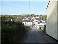
A side street in Laugharne
Laugharne has interesting side streets and townscape with a mix of well-maintained and shabby-chic buildings side-by-side in a charming and characteristic way. I approve.
Image: © Jeremy Bolwell
Taken: 19 Apr 2011
0.17 miles
10
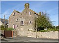
House by the shore, Laugharne
Quite a large double-pile house. The two halves appear to have floors on different levels.
Image: © Humphrey Bolton
Taken: 4 Oct 2007
0.17 miles