IMAGES TAKEN NEAR TO
Pendine, CARMARTHEN, SA33 4PX
Introduction
This page details the photographs taken nearby to SA33 4PX by members of the Geograph project.
The Geograph project started in 2005 with the aim of publishing, organising and preserving representative images for every square kilometre of Great Britain, Ireland and the Isle of Man.

There are currently over 7.5m images from over14,400 individuals and you can help contribute to the project by visiting https://www.geograph.org.uk
Image Map
Images are licensed for reuse under creativecommons.org/licenses/by-sa/2.0
Notes
- Clicking on the map will re-center to the selected point.
- The higher the marker number, the further away the image location is from the centre of the postcode.
Image Listing (2 Images Found)
Images are licensed for reuse under creativecommons.org/licenses/by-sa/2.0
Image
Details
Distance
1
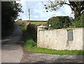
Farm entrance
This shows the entrance to Castell Toch farm, and the quiet back road it is situated on.
Image: © Lizzie
Taken: 4 Oct 2008
0.09 miles
2
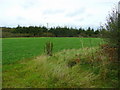
Field near Castell Toch
Rape has been sown for cropping next year.
The trees are on the southern edge of Windleway Wood.
Image: © Jonathan Billinger
Taken: 15 Oct 2008
0.20 miles