IMAGES TAKEN NEAR TO
St. Clears, CARMARTHEN, SA33 4NB
Introduction
This page details the photographs taken nearby to SA33 4NB by members of the Geograph project.
The Geograph project started in 2005 with the aim of publishing, organising and preserving representative images for every square kilometre of Great Britain, Ireland and the Isle of Man.

There are currently over 7.5m images from over14,400 individuals and you can help contribute to the project by visiting https://www.geograph.org.uk
Image Map (Loading...)


Getting Data...Please wait
Leaflet Map data © OpenStreetMap
Images are licensed for reuse under creativecommons.org/licenses/by-sa/2.0
Notes
- Clicking on the map will re-center to the selected point.
- The higher the marker number, the further away the image location is from the centre of the postcode.
Image Listing (3 Images Found)
Images are licensed for reuse under creativecommons.org/licenses/by-sa/2.0
Image
Details
Distance
1
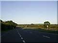
A40 Dual Carriageway near Bancyfelin
This photograph shows a Carmarthen bound stretch of the A40 dual carriageway from St Clears.
Image: © Martyn Harries
Taken: 14 Aug 2011
0.03 miles
2
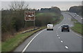
The A40 westbound towards Forge Restaurant &Services
Image: © Ian S
Taken: 21 Jan 2015
0.09 miles
3

Heol yn agosau at ffordd ddeuol / A road approaches a dual carriageway
Heol fach yn agosau at ffordd ddeuol frysur yr A40.
A minor road approaches the busy A40 dual carriageway.
Image: © Alan Richards
Taken: 18 Aug 2023
0.23 miles