IMAGES TAKEN NEAR TO
New Mill, St. Clears, CARMARTHEN, SA33 4HS
Introduction
This page details the photographs taken nearby to SA33 4HS by members of the Geograph project.
The Geograph project started in 2005 with the aim of publishing, organising and preserving representative images for every square kilometre of Great Britain, Ireland and the Isle of Man.

There are currently over 7.5m images from over14,400 individuals and you can help contribute to the project by visiting https://www.geograph.org.uk
Image Map
Images are licensed for reuse under creativecommons.org/licenses/by-sa/2.0
Notes
- Clicking on the map will re-center to the selected point.
- The higher the marker number, the further away the image location is from the centre of the postcode.
Image Listing (6 Images Found)
Images are licensed for reuse under creativecommons.org/licenses/by-sa/2.0
Image
Details
Distance
1
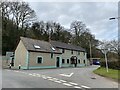
Corner house
Argoed, a house on a road junction at the foot of Woodhouse Wood.
Image: © Alan Hughes
Taken: 22 Mar 2021
0.17 miles
2
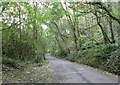
Tree lined road
Looking back up the road through the lower end of Woodhouse Wood. This is the end (or start) of the woodland section of this road.
Image: © Lizzie
Taken: 4 Oct 2008
0.19 miles
3
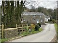
New Mill
In an area characterised by small hills and streams it’s not surprising to find old mills. This one was once new!
Image: © Alan Hughes
Taken: 22 Mar 2021
0.21 miles
4
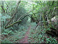
Llwybr coedog / Wooded path
Llwybr coedog yn mynd i gyfeiriad pentre Llanddowror.
A wooded path heading in the direction of Llanddowror (trans. church of the water drinkers)
Image: © Alan Richards
Taken: 10 Sep 2018
0.23 miles
5
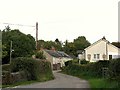
New Mill
This small settlement is on a cross roads.
Image: © Lizzie
Taken: 4 Oct 2008
0.24 miles
6
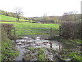
Muddy footpath and stile
The footpath leads straight across the field ahead, if you can get to the stile
Image: © Alistair Hare
Taken: 9 Nov 2010
0.25 miles